support@meisterdrucke.com  ·  0043 4257 29415

Deutsch English Italiano Español Français Nederlands Português Svenska Polski Dansk
Search by artist, work title or style – e.g. Monet, Starry Night, Impressionism, Hokusai wave, nude. Describe the scene – e.g. green meadow, abstract with lots of red, dark oil painting, standing nude next to a tree.

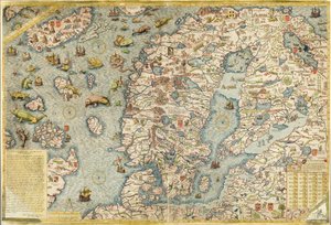
Northern Europe, from an Atlas of the World in 33 Maps, Venice, 1st September 1553 by Battista Agnese

Northern Europe, from an Atlas of the World in 33 Maps, Venice, 1st September 1553

(Northern Europe, from an Atlas of the World in 33 maps, Venice, 1st September 1553 (ink on vellum) (see also 330952))


Battista Agnese

€ 141.21
Includes 13.5% VAT
   Configure art print
1553  ·  ink on vellum  ·  Image ID: 93448

Nonclassified artists  ·  Cartography

Northern Europe, from an Atlas of the World in 33 Maps, Venice, 1st September 1553 by Battista Agnese. Available as an art print on canvas, photo paper, watercolor board, natural paper, or Japanese paper.
cartography · mapping · european · scandinavia · england · ireland · iceland · finland · sweden · norway · denmark · baltic sea · boat · ship · fish · sea monster · north wind · chart · Museo Correr, Venice, Italy / Bridgeman Images
Other color versions of this image  
AR/3D   View in 3D / AR zu Favoriten hinzufügen   Add to favorites    Change wall color    View picture in a room
0 Reviews

Configure art print

Picture Frame

Medium & Stretcher

Glass & Passepartout

Miscellaneous & Extras

 Save / compare configuration
Preview Icon

Summary

Gemälde
Veredelung
Keilrahmen
Museumslizenz

€ 141.21
(inkl. 20% MwSt)
   Add to cart

Bildschärfe: PERFEKT

If you'd like us to adjust the brightness, colors, or crop the image, we're happy to do this for you at no extra cost. Just get in touch!

Similar artworks selected for you

Map of Scandinavia Scandinavia, detail from the Carta Marina by Olaus Magnus, 1572 Fol. 30v Map of the Sea of Maluku, from the Scandinavia, detail from the Carta Marina by Olaus Magnus, 1572 Carta Marina, Original 1593 Map of Northern Europe Map of the Sea (Carta marina) by Olaus Magnus (1490-1557) Map of Northern Europe, from A faithful reproduction of Carta marina (a wall map of Scandinavia by Olaus Magnus published in 1539) A Map of Iceland circa 1588 Europe, from Atlas of the World in thirty-three Maps Iceland, from an Atlas of the World in 33 maps, Venice, 1st September 1553 (detail from 330951) Map of Zeeland, c. 1560 The Continent of Europe, from an Atlas of the World in 33 Maps, Venice, 1st September 1553 A Map of Iceland circa 1588 This Type of Early Vellum Sea Chart Originated in the Mediterranean in the 13th Century Jutland, Denmark Europe and Central Asia, from an Atlas of the World in 33 Maps, Venice, 1st September 1553 Northern Europe: Iceland, from Atlas of the World in thirty-three Maps Denmark - in Map of Sixteenth Century Britain and Northern France, from the A Map of Iceland Around 1588 Ireland, Great Britain, Iceland, Norway, Sweden, Finland, Greenland Double-page Map of Northern Europe Map of Ancient Europe, from Map of Iceland by Abraham Ortelius in 1570 Copy of Catalan Map of Europe, North Africa and the Middle East
Show more similar artworks

Similar artworks selected for you

Map of Scandinavia Scandinavia, detail from the Carta Marina by Olaus Magnus, 1572 Fol. 30v Map of the Sea of Maluku, from the Scandinavia, detail from the Carta Marina by Olaus Magnus, 1572 Carta Marina, Original 1593 Map of Northern Europe Map of the Sea (Carta marina) by Olaus Magnus (1490-1557) Map of Northern Europe, from A faithful reproduction of Carta marina (a wall map of Scandinavia by Olaus Magnus published in 1539) A Map of Iceland circa 1588 Europe, from Atlas of the World in thirty-three Maps Iceland, from an Atlas of the World in 33 maps, Venice, 1st September 1553 (detail from 330951) Map of Zeeland, c. 1560 The Continent of Europe, from an Atlas of the World in 33 Maps, Venice, 1st September 1553 A Map of Iceland circa 1588 This Type of Early Vellum Sea Chart Originated in the Mediterranean in the 13th Century Jutland, Denmark Europe and Central Asia, from an Atlas of the World in 33 Maps, Venice, 1st September 1553 Northern Europe: Iceland, from Atlas of the World in thirty-three Maps Denmark - in Map of Sixteenth Century Britain and Northern France, from the A Map of Iceland Around 1588 Ireland, Great Britain, Iceland, Norway, Sweden, Finland, Greenland Double-page Map of Northern Europe Map of Ancient Europe, from Map of Iceland by Abraham Ortelius in 1570 Copy of Catalan Map of Europe, North Africa and the Middle East
Show more similar artworks

More art prints by Battista Agnese

Zodiac Calendar, from an Atlas of the World in 33 Maps, Venice, 1st September 1553 The Indian Ocean, from an Atlas of the World in 33 Maps, Venice, 1st September 1553 The Continent of Europe, from an Atlas of the World in 33 Maps, Venice, 1st September 1553 Map tracing Magellan The New World, from an Atlas of the World in 33 Maps, Venice, 1st September 1553 Detail from Europe and Central Asia, from an Atlas of the World in 33 Maps, Venice, 1st September 1553 Nile river delta, Red Sea and Mount Sinai, from Atlas of the World in thirty-three Maps, by Battista Agnese Europe and Central Asia, from an Atlas of the World in 33 Maps, Venice, 1st September 1553 Nile river delta, Red Sea and Mount Sinai, from Atlas of the World in thirty-three Maps, by Battista Agnese The Kingdoms of England and Scotland, from an Atlas of the World in 33 Maps, Venice, 1st September 1553 (detail from 330949) Holy Land, Israel and Palestine: Jerusalem and the Dead Sea, from Atlas of the World in thirty-three Maps, by Battista Agnese Holy Land, Israel and Palestine: Sea of Galilee and the city of Tiberias, from Atlas of the World in thirty-three Maps, by Battista Agnese Mount Sinai and the Red Sea, from an Atlas of the World in 33 Maps, Venice, 1st September 1553 (detail from 330963) India and Malaysia, from an Atlas of the World in 33 Maps, Venice, 1st September 1553 (detail from 330955) Moschoviae Tabula, map of Russia and European cities along the Volga River
Show more works by Battista Agnese

More art prints by Battista Agnese

Zodiac Calendar, from an Atlas of the World in 33 Maps, Venice, 1st September 1553 The Indian Ocean, from an Atlas of the World in 33 Maps, Venice, 1st September 1553 The Continent of Europe, from an Atlas of the World in 33 Maps, Venice, 1st September 1553 Map tracing Magellan The New World, from an Atlas of the World in 33 Maps, Venice, 1st September 1553 Detail from Europe and Central Asia, from an Atlas of the World in 33 Maps, Venice, 1st September 1553 Nile river delta, Red Sea and Mount Sinai, from Atlas of the World in thirty-three Maps, by Battista Agnese Europe and Central Asia, from an Atlas of the World in 33 Maps, Venice, 1st September 1553 Nile river delta, Red Sea and Mount Sinai, from Atlas of the World in thirty-three Maps, by Battista Agnese The Kingdoms of England and Scotland, from an Atlas of the World in 33 Maps, Venice, 1st September 1553 (detail from 330949) Holy Land, Israel and Palestine: Jerusalem and the Dead Sea, from Atlas of the World in thirty-three Maps, by Battista Agnese Holy Land, Israel and Palestine: Sea of Galilee and the city of Tiberias, from Atlas of the World in thirty-three Maps, by Battista Agnese Mount Sinai and the Red Sea, from an Atlas of the World in 33 Maps, Venice, 1st September 1553 (detail from 330963) India and Malaysia, from an Atlas of the World in 33 Maps, Venice, 1st September 1553 (detail from 330955) Moschoviae Tabula, map of Russia and European cities along the Volga River
Show more works by Battista Agnese

More motifs from the category Cartography

American Indian Map A Map of St Paul Map of Naples, from ‘Civitates Orbis Terrarum’ by Georg Braun (1541-1622) and Frans Hogenberg (1535-90), c.1572 Map of Africa, from Nova Africa Descriptio, published in Amsterdam in the 1660s by Dutch cartographer Frederik de Wit Map of English Colonies in the Caribbean, published by Homanns Heirs, Nuremberg, c. 1750 Map of Britain and Ireland Map of Africa Map of the Operations which led to the Capitulation of Ulm, published by William Blackwood and Sons, Edinburgh and London, 1848 Map of Europe, published in 1700, Paris Map No. 1 showing the route of the Armada fleet, engraved by Augustine Ryther, 1588 Map of Asia, published in 1700, Paris Map of the Known World, from „Geographia“ World map of the different time zones, published by Blondel La Rougery in Paris c.1920 Hull, detail from the map of the North and East Ridings of Yorkshire, engraved by Jodocus Hondius (1563-1612) from John Speed’s ’Theatre of the Empire of Great Britain’, published by John Sudbury and Georg Map of the mouth of the Chicago River, Illinois with the plan of the proposed piers for improving the harbour, 1830
View More from "Cartography"

More motifs from the category Cartography

American Indian Map A Map of St Paul Map of Naples, from ‘Civitates Orbis Terrarum’ by Georg Braun (1541-1622) and Frans Hogenberg (1535-90), c.1572 Map of Africa, from Nova Africa Descriptio, published in Amsterdam in the 1660s by Dutch cartographer Frederik de Wit Map of English Colonies in the Caribbean, published by Homanns Heirs, Nuremberg, c. 1750 Map of Britain and Ireland Map of Africa Map of the Operations which led to the Capitulation of Ulm, published by William Blackwood and Sons, Edinburgh and London, 1848 Map of Europe, published in 1700, Paris Map No. 1 showing the route of the Armada fleet, engraved by Augustine Ryther, 1588 Map of Asia, published in 1700, Paris Map of the Known World, from „Geographia“ World map of the different time zones, published by Blondel La Rougery in Paris c.1920 Hull, detail from the map of the North and East Ridings of Yorkshire, engraved by Jodocus Hondius (1563-1612) from John Speed’s ’Theatre of the Empire of Great Britain’, published by John Sudbury and Georg Map of the mouth of the Chicago River, Illinois with the plan of the proposed piers for improving the harbour, 1830
View More from "Cartography"

A selection of our top sellers

Nuda veritas Evening with Clouds The Four Horsemen of the Apocalypse, ca. 1498 Nighthawks The North Cape by Moonlight, 1848 Summer Afternoon, 1865 Landscape scene from Thanatopsis, 1850 The Incredulity of St. Thomas, 1602-03 Portrait of the Philosopher and Esotericist Rudolf Steiner Pear Blossom, 1882 Native birds, including the Toucan (centre), Amazon, Brazil, from The Roundel in the Hedge Garden with a Flower Waterer Camelot, illustration from Morning in a Pine Forest Rosa banksiae (Banks
Show more artworks

A selection of our top sellers

Nuda veritas Evening with Clouds The Four Horsemen of the Apocalypse, ca. 1498 Nighthawks The North Cape by Moonlight, 1848 Summer Afternoon, 1865 Landscape scene from Thanatopsis, 1850 The Incredulity of St. Thomas, 1602-03 Portrait of the Philosopher and Esotericist Rudolf Steiner Pear Blossom, 1882 Native birds, including the Toucan (centre), Amazon, Brazil, from The Roundel in the Hedge Garden with a Flower Waterer Camelot, illustration from Morning in a Pine Forest Rosa banksiae (Banks
Show more artworks


What our customers think about us


Frequently Asked Questions about Meisterdrucke


Personalizing your art print at Meisterdrucke is simple and intuitive: Choose a frame, set the image size, pick a printing medium, and add suitable glazing or a stretcher frame. We also offer additional customization options like mats, fillets, and spacers. If you have any questions, our customer service team is ready to help you create your perfect artwork.

At Meisterdrucke, you can visualize your configured artwork directly in your own room. Simply upload a photo of your space and see how the artwork looks in it. If you're visiting us on a mobile device — phone or tablet — our augmented reality feature brings the picture to life and projects it right into your room. A unique experience that combines art and technology.

Choosing the right medium is often a matter of personal taste. To give you a better idea, we've provided some images for each medium. We also offer a sample set of all paper variants, so you can decide not just visually but by touch as well. You can order the sample set free of charge — only shipping costs apply.

Don't worry! At Meisterdrucke, we don't just process orders mechanically. Every order is manually reviewed by our team. If we spot any inconsistencies or issues with your configuration, we'll get in touch with you right away. And of course, our friendly and patient support team is always here to help you with your configuration. We'll work with you by phone or email to adjust your image so the final result is exactly what you had in mind.


Still have questions?

Are you interested in an art print from our manufactory but still unsure? Do you need advice on choosing the medium or help with the order?

Our experts are happy to assist you.

+43 4257 29415
support@meisterdrucke.com
Mo-Do: 7:00 - 16:00 | Fr: 7:00 - 13:00

Still have questions?

Are you interested in an art print from our manufactory but still unsure? Do you need advice on choosing the medium or help with the order?

Our experts are happy to assist you.

+43 4257 29415
support@meisterdrucke.com
Mo-Do: 7:00 - 16:00 | Fr: 7:00 - 13:00


Meisterdrucke

   Kärntner Strasse 46
        9586 Finkenstein am Faaker See
        Austria
        +43 4257 29415
        support@meisterdrucke.com
Other languages

                   
Erfahrungen & Bewertungen zu Meisterdrucke
Post.at DHL Express Quehenberger Cargoboard
Kaiser Franz Joseph

Meisterdrucke
Kärntner Strasse 46
9586 Finkenstein am Faaker See · Austria
+43 4257 29415 · support@meisterdrucke.com
Post.at DHL Express Quehenberger Cargoboard


(c) 2026 meisterdrucke.ie