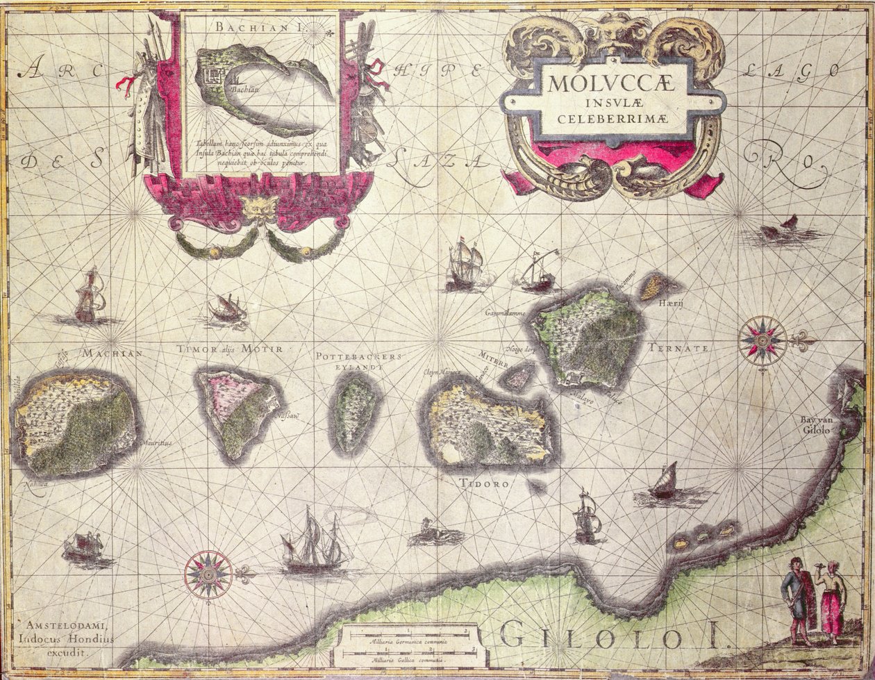
Map of The Moluccan Island, Engraved by Jodocus Hondius, 1630 by Willem Janszoon Blaeu

Map of The Moluccan Island, Engraved by Jodocus Hondius, 1630

(Map of The Moluccan Island, engraved by Jodocus Hondius, 1630 (colour engraving))


Willem Janszoon Blaeu

€ 127.87
Enthält 13.5% MwSt.
   Configure art print
Undated  ·  colour lithograph  ·  Picture ID: 40582

Nonclassified artists  ·  Cartography

Map of The Moluccan Island, Engraved by Jodocus Hondius, 1630 by Willem Janszoon Blaeu. Available as an art print on canvas, photo paper, watercolor board, uncoated paper or Japanese paper.
east indies · cartography · geography · geographical · maluku · moluccas · dutch east indies · mapping · indonesia · islands · isles · halmahera · gilolo · spice islands · timor · tidor · machian · henrij · cartouche · asian · iles · Moluques · Private Collection / Bridgeman Images
Other color variations of this picture  
AR/3D   View in 3D / AR zu Favoriten hinzufügen   Add to favorites    Select wall color    View painting in a room
0 Reviews

Configure art print

Picture Frame

Medium & Stretcher

Glass & Passepartout

Miscellaneous & Extras

 Save / compare configuration
Preview Icon

Summary

Gemälde
Veredelung
Keilrahmen
Museumslizenz

€ 127.87
(inkl. 20% MwSt)
   Add to cart

Bildschärfe: PERFEKT

Should you desire adjustments to brightness and color, or a custom crop of the motif, we are happy to make these changes at no additional cost to you. Please do not hesitate to contact us.

Similar artworks selected for you

L East Friesland 1584 Map Map showing the Island of Crete, c.1570, by Abraham Ortelius Majorca, Minorca, and Ibiza, including the coasts of Catalonia and Valencia, in Map of Republic of Genoa, Italy Map of the island of Malta Nice on the Mediterranean Malta The coast of England from the Southforeland to Orfordness Map Part of the Coast of Norway and Sweden Freti Magellanici ac Novi Freti Vulgo Le Maire Exactissima Delineatio Map of Part of the Coast of Norway and Sweden Map of the Coasts of Flanders, Normandy, and England Map of the Coast of Flanders, Normandy and England The Windward Passage from Jamaica, Between the East End of Cuba, and the West End of Hispaniola Gulf of Mexico and the Caribbean, from Blaeu Map of Malta and Gozo, c.1650 The Republic of Genoa, Map by Jan Baptist Vrients from Theatrum Orbis Terrarum by Abraham Ortelius Republic of Genoa, Map by Jan Baptist Vrients, Copper engraving Bristol Channel European Coast, Map on Parchment by Willem and Joan Blaeu Map of Duchy of Monferrato, Engraving from Regionum Italiae Pas-caert van de Canael, Tusschen Engelandt en Vranckryck, van Pleymuyen tot an de Sorlinges, als mede van Portbimel tot aen Heyssant Map of East Africa and Madagascar
Show more similar artworks

Other art prints by Willem Janszoon Blaeu

World Map, from Asia noviter delineata Africa Nova A 17th Century Map by Willem Janszoon Blaeu, Showing Modern-Day Indonesia and Parts of South East Asia Frontispiece from the Sailing Manual Map of Russia From: Theatrum Orbis Terrarum Map of The Moluccan Island, Engraved by Jodocus Hondius, 1630 Map of the Holy Land, published in Amsterdam, 1629 Map of Map of Siberia and China from Le Theatre du Monde or Nouvel Atlas, 1645 Map of Russia From: Theatrum Orbis Terrarum View of Rio de Janeiro, Brazil, 1600 Map of the Lower Elbe, 1:160 000, Copper Engraving, 1628 The Moscow Kremlin Map of the 16th Century Castellum Urbis Moskvae Rügen From: Theatrum Orbis Terrarum
Discover more works by Willem Janszoon Blaeu

Other motives from the category Cartography

Map of the Island of Martinique, 1599 Map of Countries First Discovered by Christopher Columbus (1451-1506) 1500 Falkland Islands and Patagonia, from a Series of World Maps published by John Tallis and Co., New York and London, 1850s Part of Africa, from an Atlas of the World in 33 Maps, Venice, 1st September 1553 (detail) Panoramic View of the Baltic Sea and the Route of the Fleet from Spithead to St. Petersburg, from Government Maps and Charts Made Under the Supervision of an Officer in the Expedition Under Sir Charle Map Showing the Extent of Work During the Haussmann Period of Development in Paris from 1854-71, 1871 Map of the City of New York Patagonia, from a Series of World Maps published by John Tallis und Co., New York and London, 1850s The Graphic Map of Bulgaria, Eastern Roumelia, the Turkish Empire in Europe Detail of Copy of a Catalan Map of Europe and North Africa, presented to Charles V of France in 1381 Map of the World using the Mercator Projection, from Map of the Siege of Sebastopol, 18th June 1855 Map of the Battle of Borodino, Published by William Blackwood and Sons, Edinburgh and London, 1848 Town Map of Cairo Map of the New Simplon Pass, 1803
View More from "Cartography"

Excerpt from our top sellers

Cosmic Cliffs in the Carina Nebula Sheerness as Seen from the Nore Lake Thun with Symmetrical Reflection Waterlilies at Sunset Cartoon: Series Lady in Yellow The Ice Sea Woman in a Yellow Dress Summer Night by the Beach Three White Cottages in Saintes-Maries Nymphs and Satyr Dining Room on the Garden, 1934-35 Stein on the Danube (District of Krems) Ascending Path Fish Magic
Show More Artworks


What our customers think about us


Frequently Asked Questions about Meisterdrucke


Personalizing your art print at Meisterdrucke is a simple and intuitive process that allows you to design an artwork exactly to your specifications: Choose a frame, determine the image size, decide on a printing medium, and add suitable glazing or a stretcher frame. We also offer customization options such as mats, fillets, and spacers. Our customer service is available to help you design your perfect artwork.

At Meisterdrucke, you have the fascinating option to visualize the artwork you configured directly in your own space. For a tailored preview, simply upload a photo of your room and let the artwork appear on it. If you visit us via a mobile device, be it a phone or tablet, our augmented reality feature brings the image to life and seamlessly projects it into your space. An experience that uniquely combines art and technology.

Choosing the medium is often a matter of personal taste. To give you a clearer idea, we have provided some images for each medium. For a holistic experience, we also offer you a sample set of all paper variants so you can make a decision not just visually but also haptically. You can take advantage of the sample set free of charge – only the shipping costs will apply. You can order the sample set directly.

Do not worry. At Meisterdrucke, we do not proceed mechanically. We manually review each order. If there are any inconsistencies or peculiarities in the configuration, we will immediately contact you. Of course, our courteous and patient support is always at your side to assist you with the configuration. Together with you, we adjust your image by phone or email so that the final result exactly meets your expectations.


Do you have any questions?

Are you interested in an art print from our manufactory but still unsure? Do you need advice on choosing the medium or help with the order?

Our experts are happy to assist you.

+43 4257 29415
support@meisterdrucke.com
Mo-Do: 7:00 - 16:00 | Fr: 7:00 - 13:00

Do you have any questions?

Are you interested in an art print from our manufactory but still unsure? Do you need advice on choosing the medium or help with the order?

Our experts are happy to assist you.

+43 4257 29415
support@meisterdrucke.com
Mo-Do: 7:00 - 16:00 | Fr: 7:00 - 13:00


Meisterdrucke

   Kärntner Strasse 46
        9586 Finkenstein am Faaker See
        Austria
        +43 4257 29415
        support@meisterdrucke.com
Other languages

                   
Erfahrungen & Bewertungen zu Meisterdrucke
Post.at DHL Express Quehenberger Cargoboard
Kaiser Franz Joseph

Meisterdrucke
Kärntner Strasse 46
9586 Finkenstein am Faaker See · Austria
+43 4257 29415 · office@meisterdrucke.com
Post.at DHL Express Quehenberger Cargoboard


Meisterdrucke 2707 Bewertungen auf ProvenExpert.com

(c) 2025 meisterdrucke.ie