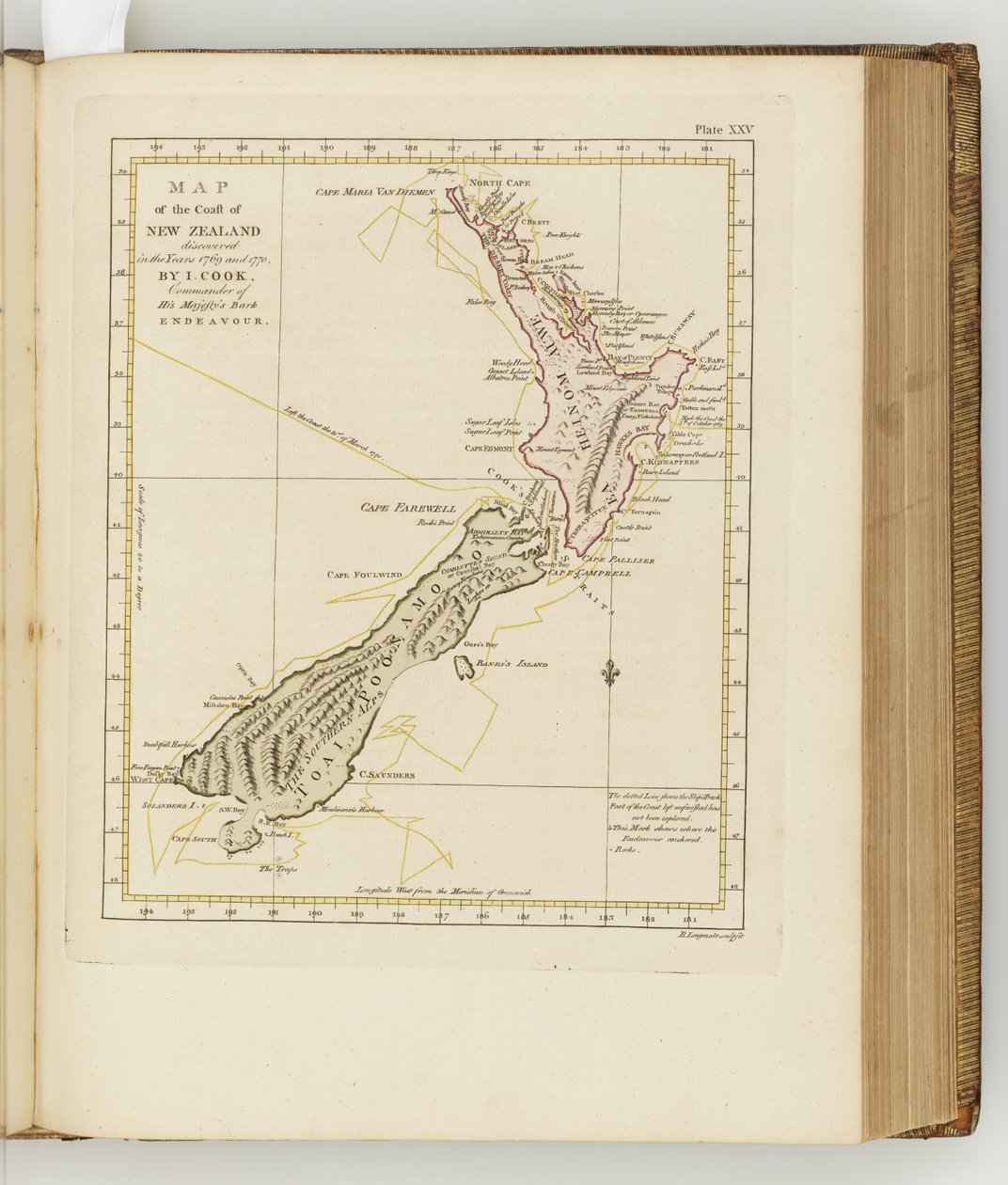
Map of the Coast of New Zealand, Illustration from A Journal of a Voyage to the South Seas: In His Majesty

Map of the Coast of New Zealand, Illustration from A Journal of a Voyage to the South Seas: In His Majesty's Ship, the Endeavour, 1794

(Map of the coast of New Zealand, illustration from A journal of a voyage to the South Seas : in His Majestys ship, the Endeavour, 1794 (hand-coloured engraving))


Sydney

€ 122.47
Enthält 13.5% MwSt.
   Configure art print
1794  ·  hand-coloured engraving  ·  Picture ID: 644011

Nonclassified artists

Map of the Coast of New Zealand, Illustration from A Journal of a Voyage to the South Seas: In His Majesty's Ship, the Endeavour, 1794 by Sydney. Available as an art print on canvas, photo paper, watercolor board, uncoated paper or Japanese paper.
cartography · australasia · book · hms endeavour · captain cook · coastline · discovery · expedition · new zealand · enlightenment · adventure · oceania · historic · australia · voyage · exploration · journal · georgian · joseph banks · maps · south seas · british · naval · mapping · james cook · colonisation · australian · endeavour · english · coast · solander · illustration · navigation · Dixson Galleries, State Library of New South Wales / Bridgeman Images
zu Favoriten hinzufügen   Add to favorites    Select wall color    View painting in a room AR/3D   View in 3D / AR
0 Reviews

Configure art print

Picture Frame

Medium & Stretcher

Glass & Passepartout

Miscellaneous & Extras

 Save / compare configuration
Preview Icon

Summary

Gemälde
Veredelung
Keilrahmen
Museumslizenz

€ 122.47
(inkl. 20% MwSt)
   Add to cart

Bildschärfe: PERFEKT

Should you desire adjustments to brightness and color, or a custom crop of the motif, we are happy to make these changes at no additional cost to you. Please do not hesitate to contact us.

Similar artworks selected for you

Chart of New Zealand, explored in 1769 and 1770 by Lieutenant J. Cook Arabian Gulf or Red Sea, engraved by Thomas Bowen, 1788 New discoveries made in 1775, 67 and 69 in the South Seas, engraving by G. Zuliani taken from Tome I of the Newest Atlas published in Venice in 1776 by Antonio Zatta Chart of Terra Australis, South Coast, Sheet III Plans of Ports, Dalrymple, Alexander published in 1791 ID Number 41167-2001 A plane chart of part of the Gulf of Persia, partly corrected by Lieut. Edward Harvey 1778 Map of France, c.1693 A Map Exhibiting All the New Discoveries in the Interior Parts of North America Congo. Angola. Cafres. Monoemugi. Monomotapa. Zanguebar & Madagascar, 1701 Acadia, the Provinces of Sagadahoc and Maine, New Hampshire, Rhode Island and Part of Massachusetts and Connecticut, Engraving by G. Zuliani West Coast of Africa, from Lisbon to Sierra Leone, from Chart of the River Thames and Estuary Plan of Choul and Surat River Chart of Discoveries Made in the South Pacific Ocean in His Majesty Plymouth Bay A Plan of the Navigable Canals now making in the Inland Parts of the Kingdom, for opening a Communication to the Ports of London, Bristol, Liverpool and Hull, with the adjacent Towns and Rivers. By James Brindley Engineer. Drawn by Rob.t Whitworth. Chart of Port Hood Maps 8.Tab.C.8.80 Plans of Ports, Dalrymple, Alexander Published in 1791. A Plane Chart of the Gulf of Persia, by Lieut. John Cant 1773 The south west coast of Ireland from the Staggs of Castle Haven to Dursey I. Surveyed and navigated by M. Mackenzie Sen. 1775. Map of the Coast of Africa, 1753 Eastern Part of Canada, Northern Nova Scotia and Part of Labrador, Engraving by G. Zuliani Map of Chile, Patagonia, Tierra del Fuego and the Falkland Islands, c.1798 Island of Minorca and the Plan of the Port and the City of Mahon and Its Forts, Engraving by G. Zuliani from the Newest Atlas Map showing the Gulf of Mexico, Carte reduite du golphe de Mexique et des isles de l Map of Ancient Egypt, drawn and engraved by Sydney Hall, c.1826 Fourth Map of Europe: Ptolemy Rome 1490 Land of the Ottawa and Kilistine Indians Around Lake Superior and a Supplement of Eastern Florida, Engraving by G. Zuliani from Tome I of the "Newest Atlas" Chart of Terra Australis by M Flinders, Commr of His Majesty Map of the Coast of Tonkin and Cochinchina
Show more similar artworks

Other art prints by Sydney

Various Kinds of Instruments, Utensils &c of the Inhabitants of New Zealand, Illustration from A Journal of a Voyage to the South Seas: In His Majesty Illustration from A Journal of a Voyage to the South Seas: In His Majesty Head of Otegoongoon, Illustration from A Journal of a Voyage to the South Seas: In His Majesty The Heads of Six Men, Illustration from A Journal of a Voyage to the South Seas: In His Majesty Two of the Natives of New Holland, Illustration from A Journal of a Voyage to the South Seas: In His Majesty A Woman and a Boy, Natives of Otaheite, Illustration from A Journal of a Voyage to the South Seas: In His Majesty Illustration from A Journal of a Voyage to the South Seas: In His Majesty A Native of Otaheite, Illustration from A Journal of a Voyage to the South Seas: In His Majesty Illustration from A Journal of a Voyage to the South Seas: In His Majesty View of the Great Peak, Illustration from A Journal of a Voyage to the South Seas: In His Majesty Heads of Diverse Natives, Illustration from A Journal of a Voyage to the South Seas: In His Majesty Illustration from A Journal of a Voyage to the South Seas: In His Majesty A War Canoe of New Zealand, Illustration from A Journal of a Voyage to the South Seas: In His Majesty The Manner in Which the New Zealand Warriors Defy Their Enemies, Illustration from A Journal of a Voyage to the South Seas: In His Majesty A New Zealand Warrior and His Wife, Illustration from A Journal of a Voyage to the South Seas: In His Majesty
Discover more works by Sydney

Excerpt from our top sellers

Reclining Semi-Nude (Masturbating) The Artist Intersecting Lines Isle of the Dead. 1883 (Third Version of Five) The Dutch Proverbs Girl with a Rake in Fjord Landscape The Meurthe Boating Party Philosophy Terrace of the Café on the Place du Forum in Arles in the Evening Still Life with Coffee The Boulevard Montmartre on a Winter Morning Portrait of a Woman, 1910 The Seasons: Autumn, 1896 The Destruction of an Empire Poster for the Vienna Secession Exhibition
Show More Artworks


What our customers think about us


Frequently Asked Questions about Meisterdrucke


Personalizing your art print at Meisterdrucke is a simple and intuitive process that allows you to design an artwork exactly to your specifications: Choose a frame, determine the image size, decide on a printing medium, and add suitable glazing or a stretcher frame. We also offer customization options such as mats, fillets, and spacers. Our customer service is available to help you design your perfect artwork.

At Meisterdrucke, you have the fascinating option to visualize the artwork you configured directly in your own space. For a tailored preview, simply upload a photo of your room and let the artwork appear on it. If you visit us via a mobile device, be it a phone or tablet, our augmented reality feature brings the image to life and seamlessly projects it into your space. An experience that uniquely combines art and technology.

Choosing the medium is often a matter of personal taste. To give you a clearer idea, we have provided some images for each medium. For a holistic experience, we also offer you a sample set of all paper variants so you can make a decision not just visually but also haptically. You can take advantage of the sample set free of charge – only the shipping costs will apply. You can order the sample set directly.

Do not worry. At Meisterdrucke, we do not proceed mechanically. We manually review each order. If there are any inconsistencies or peculiarities in the configuration, we will immediately contact you. Of course, our courteous and patient support is always at your side to assist you with the configuration. Together with you, we adjust your image by phone or email so that the final result exactly meets your expectations.


Do you have any questions?

Are you interested in an art print from our manufactory but still unsure? Do you need advice on choosing the medium or help with the order?

Our experts are happy to assist you.

+43 4257 29415
support@meisterdrucke.com
Mo-Do: 7:00 - 16:00 | Fr: 7:00 - 13:00

Do you have any questions?

Are you interested in an art print from our manufactory but still unsure? Do you need advice on choosing the medium or help with the order?

Our experts are happy to assist you.

+43 4257 29415
support@meisterdrucke.com
Mo-Do: 7:00 - 16:00 | Fr: 7:00 - 13:00


Meisterdrucke

   Kärntner Strasse 46
        9586 Finkenstein am Faaker See
        Austria
        +43 4257 29415
        support@meisterdrucke.com
Other languages

                   
Erfahrungen & Bewertungen zu Meisterdrucke
Partner Logos

Kaiser Franz Joseph

Meisterdrucke
Kärntner Strasse 46
9586 Finkenstein am Faaker See · Austria
+43 4257 29415 · office@meisterdrucke.com
Partner Logos


(c) 2025 meisterdrucke.ie