support@meisterdrucke.com  ·  0043 4257 29415

Deutsch English Italiano Español Français Nederlands Português Svenska Polski Dansk
Search by artist, work title or style – e.g. Monet, Starry Night, Impressionism, Hokusai wave, nude. Describe the scene – e.g. green meadow, abstract with lots of red, dark oil painting, standing nude next to a tree.

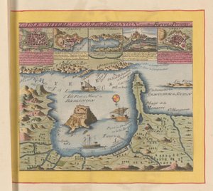
Ms 988 volume 3 fol.31 Map of Concarneau, from the ’Atlas Louis XIV’, 1683-88 by Sebastien Le Prestre de Vauban

Ms 988 volume 3 fol.31 Map of Concarneau, from the ’Atlas Louis XIV’, 1683-88

(Ms 988 volume 3 fol.31 Map of Concarneau, from the 'Atlas Louis XIV', 1683-88 )


Sebastien Le Prestre de Vauban

€ 151.9
Includes 13.5% VAT
   Configure art print
1688  ·  Gouache on paper  ·  Image ID: 115296

Nonclassified artists  ·  Cartography

Ms 988 volume 3 fol.31 Map of Concarneau, from the ’Atlas Louis XIV’, 1683-88 by Sebastien Le Prestre de Vauban. Available as an art print on canvas, photo paper, watercolor board, natural paper, or Japanese paper.
plan · coast · harbour · port · Service Historique de L'Armee et de L'Air, Vincennes, France / Bridgeman Images
AR/3D   View in 3D / AR zu Favoriten hinzufügen   Add to favorites    Change wall color    View picture in a room
0 Reviews

Configure art print

Picture Frame

Medium & Stretcher

Glass & Passepartout

Miscellaneous & Extras

 Save / compare configuration
Preview Icon

Summary

Gemälde
Veredelung
Keilrahmen
Museumslizenz

€ 151.9
(inkl. 20% MwSt)
   Add to cart

Bildschärfe: PERFEKT

If you'd like us to adjust the brightness, colors, or crop the image, we're happy to do this for you at no extra cost. Just get in touch!

Similar artworks selected for you

Map of the town and citadel of Bellisle, from the Map of the Environs of the Town and Castle of Oléron, from the Atlas of Louis XIV Louis XIV Atlas, map of Collioure Map and Plan of Saint-Malo, from the Plan of Le Havre, from the Allegorical Map of the Stages of Love Flanders, Belgium (engraving) Plan and Map of Saint-Jean-Pied-de-Port, from the Atlas Louis XIV, 1683-88 Fort Rosalie des Natchez Fol. 40v, Map of the Magellan Straits, from French Guiana, South America State of Lucca, Italy Map of Smerwick, Ireland, Showing the English Earthwork with Two Guns for Attacking the Spanish Fort and English Soldiers Marching Out of Castell More City of Goa in India, Engraving by Theodor de Bry from Travel account of the voyage of the sailor Jan Huyghen van Linschoten to Portuguese East India 1579-1592 Plan and Map of the Town and Citadel of Bayonne, from the Ms. 988 Vol.3, fol.61 Navigation Chart of Brittany Coast Plan of the Town and Harbour of Cartagena, Colombia Plan of the Citadel of Turin During the Siege of 1640 The Novi Belgii Map of New York, New Jersey and Pennsylvania Valloton St Augustine Ms. 987, Vol.2 fol.63 Plan of Toulon, from the Map of the Republic of Genoa Bristol Channel Map of the Coast near Hyères and the Nearby Îles d Strait of Magellan, Tierra del Fuego, from Map of Saint-Quentin, from the Oversize Atlas Titled
Show more similar artworks

More art prints by Sebastien Le Prestre de Vauban

Ms. 986, Vol. 1, Square Fort in Antibes, Fortification by Vauban (17th Century) Ms 988, volume 3, fol. 45, plan and map of the town and citadel of Bayonne, from the Ms. 986, Vol. 1, Plan and Map of Cambrai, from the “Atlas Louis XIV”, 1683-88 Ms 988 volume 3 fol. 33 Map of the town and citadel of Belle-Île, from the “Atlas Louis XIV”, 1683-88 Ms. 986, Vol. 3, fol. 63 Plan and Map of Toulon, from the “Atlas Louis XIV”, 1683-88 Ms 988 Vol. 3 fol. 29, Map and plan of Saint-Malo, from the Ms. 988 Vol. 3, fol. 61 Map of Paris and its Surroundings, from Ms. 988, Vol.3 fol.10 Map of Saint-Quentin, from the ’Atlas Louis XIV’, 1683-88 Map of the Environs of the Town and Castle of Oléron, from the Atlas of Louis XIV Plan and Map of the town, citadel and surroundings of Amiens, from the Plan of Rochefort and its surroundings, from the Ms 988 volume 3 fol.31 Map of Concarneau, from the ’Atlas Louis XIV’, 1683-88 Plan and Map of Saint-Jean-Pied-de-Port, from the Atlas Louis XIV, 1683-88
Show more works by Sebastien Le Prestre de Vauban

More motifs from the category Cartography

Map of Augsburg, from Map of the Battles of Smolensk and Valtellina, published by William Blackwood and Sons, Edinburgh and London, 1848 Renaissance map of Europe, after Jacopo Russo, 1528 Map of Florence, 1843 and 1866 (for detail see 100311) An Astronomer, detail from a map of the planets, from ‘A Celestial Atlas, or The Harmony of the Universe’ (Atlas coelestis seu harmonia macrocosmica), published by Joannes Janssonius, Amsterdam, 1660-61 Geological Map of the Kutch Region of India, Geological Survey of India 1868-69 Ms. Ital. 550.0.3.15, fol. 4v-5r, Map of Africa and the Cape of Good Hope, from the Map of Rome, from the “Speculum Romanae Magnificentiae” published in 1562 Ayer MS 1801 Map 1: Map of lands in the Tultepec and Jaltocan regions adjacent to the Hacienda de Santa Ines, Mexico, published 1569 Map of Aegyptus Antiqua (Ancient Egypt), drawn and engraved by Sydney Hall, c. 1826 Map of Mexico and Central America, from the Map of the Austro-Hungarian Empire, illustration from a French geography school textbook, 1905 Map of Ireland Showing the Provinces of Ulster, Munster, Connaught and Leinster, by Johann B. Homann, c. 1730 Map of Epirus for “Andromache” by Jean Racine, from Volume I of “Research on the Costumes and Theatre of All Nations”, 1802 Map of Britain in 792, from
View More from "Cartography"

A selection of our top sellers

The Sunday Walk Flowering Garden in Spring Saturn devouring his son Fish Magic Griffin Facing the Throne, Throne Room, Knossos, Crete 1550-1450 BC Church in Unterach on Lake Attersee Montage of 8 pages from Cresques Blue, 1922 Standing Male Nude Architects Dream Lady with a Fan Mori (Forest) Mont Sainte-Victoire Luncheon of the Boating Party Kneeling Woman in an Orange-Red Dress
Show more artworks


What our customers think about us


Frequently Asked Questions about Meisterdrucke


Personalizing your art print at Meisterdrucke is simple and intuitive: Choose a frame, set the image size, pick a printing medium, and add suitable glazing or a stretcher frame. We also offer additional customization options like mats, fillets, and spacers. If you have any questions, our customer service team is ready to help you create your perfect artwork.

At Meisterdrucke, you can visualize your configured artwork directly in your own room. Simply upload a photo of your space and see how the artwork looks in it. If you're visiting us on a mobile device — phone or tablet — our augmented reality feature brings the picture to life and projects it right into your room. A unique experience that combines art and technology.

Choosing the right medium is often a matter of personal taste. To give you a better idea, we've provided some images for each medium. We also offer a sample set of all paper variants, so you can decide not just visually but by touch as well. You can order the sample set free of charge — only shipping costs apply.

Don't worry! At Meisterdrucke, we don't just process orders mechanically. Every order is manually reviewed by our team. If we spot any inconsistencies or issues with your configuration, we'll get in touch with you right away. And of course, our friendly and patient support team is always here to help you with your configuration. We'll work with you by phone or email to adjust your image so the final result is exactly what you had in mind.


Still have questions?

Are you interested in an art print from our manufactory but still unsure? Do you need advice on choosing the medium or help with the order?

Our experts are happy to assist you.

+43 4257 29415
support@meisterdrucke.com
Mo-Do: 7:00 - 16:00 | Fr: 7:00 - 13:00

Still have questions?

Are you interested in an art print from our manufactory but still unsure? Do you need advice on choosing the medium or help with the order?

Our experts are happy to assist you.

+43 4257 29415
support@meisterdrucke.com
Mo-Do: 7:00 - 16:00 | Fr: 7:00 - 13:00


Meisterdrucke

   Kärntner Strasse 46
        9586 Finkenstein am Faaker See
        Austria
        +43 4257 29415
        support@meisterdrucke.com
Other languages

                   
Erfahrungen & Bewertungen zu Meisterdrucke
Post.at DHL Express Quehenberger Cargoboard
Kaiser Franz Joseph

Meisterdrucke
Kärntner Strasse 46
9586 Finkenstein am Faaker See · Austria
+43 4257 29415 · support@meisterdrucke.com
Post.at DHL Express Quehenberger Cargoboard


(c) 2026 meisterdrucke.ie