support@meisterdrucke.com  ·  0043 4257 29415

Deutsch English Italiano Español Français Nederlands Português Svenska Polski Dansk
Search by artist, work title or style – e.g. Monet, Starry Night, Impressionism, Hokusai wave, nude. Describe the scene – e.g. green meadow, abstract with lots of red, dark oil painting, standing nude next to a tree.

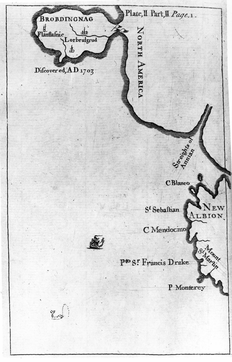
Map of Brobdingnag, illustration from the first edition of

Map of Brobdingnag, illustration from the first edition of 'Gulliver's Travels' by Jonathan Swift

(Map of Brobdingnag, illustration from the first edition of 'Gulliver's Travels' by Jonathan Swift, 1726 (print))


English School

€ 139.33
Enthält 13.5% MwSt.
   Configure art print
1726  ·  print  ·  Image ID: 109479

Cultural Circles  ·  Cartography

Map of Brobdingnag, illustration from the first edition of 'Gulliver's Travels' by Jonathan Swift by English School. Available as an art print on canvas, photo paper, watercolor board, natural paper, or Japanese paper.
novel · story · fictional place · north america · new albion · peninsular · maps · imaginary · country · countries · Private Collection / Bridgeman Images
AR/3D   View in 3D / AR zu Favoriten hinzufügen   Add to favorites    Change wall color    View picture in a room
0 Reviews

Configure art print

Picture Frame

Medium & Stretcher

Glass & Passepartout

Miscellaneous & Extras

 Save / compare configuration
Preview Icon

Summary

Gemälde
Veredelung
Keilrahmen
Museumslizenz

€ 139.33
(inkl. 20% MwSt)
   Add to cart

Bildschärfe: PERFEKT

If you'd like us to adjust the brightness, colors, or crop the image, we're happy to do this for you at no extra cost. Just get in touch!

Similar artworks selected for you

Map showing location of Brobdingnag from first edition of Gulliver Map showing location of the Houyhnhnms Land from first edition of Gulliver Map of Central America (Panama) from a Spanish Volume of Trips Colonial America: the Dutch Colony of New Netherland Map No.9 showing the route of the Armada fleet, engraved by Augustine Ryther, 1588 Map No.10 showing the route of the Armada fleet, engraved by Augustine Ryther Atlantis: a map showing the location of the mythical continent, c1882 1956 Map No.2 Showing the route of the Armada fleet, engraved by Augustine Ryther, 1588 Map of Pennsylvania at the beginning of the 18th century, from Humphrey Map of New York about the middle of the 18th century The Rio Ianeiro, from the Travels of Villegagnon and Jean le Leri in Brazil 1557-1558 Map of Meridional America from a Spanish volume of trips from the beginning of the 17th century Turtle Island and Santo Domingo from a 17th century map by Pierre Vandier Connecticut Plan of Rhodes (Rodos) - in Map No.7 Showing the Route of the Armada Fleet, Engraved by Augustine Ryther, 1588 Spithead, Portsmouth and the Isle of Wight, 1884 Map No.6 showing the route of the Armada fleet, engraved by Augustine Ryther, 1588 The Capture of Cádiz in 1596 Map Showing the route of the Armada fleet, engraved by Augustine Ryther Map including Massachusetts Bay The Bombardment of Alexandria: Sketch Map Plan of the Bombardment of Alexandria Map of Lilliput and Blefuscu, from the first edition of Wolfe Map of Laputa, Balnibari, Luggnagg, Glubbdubdrib and Japan, illustration from the first edition of Map No. 8 showing the route of the Armada fleet, engraved by Augustine Ryther, 1588 A Plan of the City and Country Around Algiers Plan of West Point, the Key Fort that Benedict Arnold Plotted to Deliver to the British During the War of Independence
Show more similar artworks

Similar artworks selected for you

Map showing location of Brobdingnag from first edition of Gulliver Map showing location of the Houyhnhnms Land from first edition of Gulliver Map of Central America (Panama) from a Spanish Volume of Trips Colonial America: the Dutch Colony of New Netherland Map No.9 showing the route of the Armada fleet, engraved by Augustine Ryther, 1588 Map No.10 showing the route of the Armada fleet, engraved by Augustine Ryther Atlantis: a map showing the location of the mythical continent, c1882 1956 Map No.2 Showing the route of the Armada fleet, engraved by Augustine Ryther, 1588 Map of Pennsylvania at the beginning of the 18th century, from Humphrey Map of New York about the middle of the 18th century The Rio Ianeiro, from the Travels of Villegagnon and Jean le Leri in Brazil 1557-1558 Map of Meridional America from a Spanish volume of trips from the beginning of the 17th century Turtle Island and Santo Domingo from a 17th century map by Pierre Vandier Connecticut Plan of Rhodes (Rodos) - in Map No.7 Showing the Route of the Armada Fleet, Engraved by Augustine Ryther, 1588 Spithead, Portsmouth and the Isle of Wight, 1884 Map No.6 showing the route of the Armada fleet, engraved by Augustine Ryther, 1588 The Capture of Cádiz in 1596 Map Showing the route of the Armada fleet, engraved by Augustine Ryther Map including Massachusetts Bay The Bombardment of Alexandria: Sketch Map Plan of the Bombardment of Alexandria Map of Lilliput and Blefuscu, from the first edition of Wolfe Map of Laputa, Balnibari, Luggnagg, Glubbdubdrib and Japan, illustration from the first edition of Map No. 8 showing the route of the Armada fleet, engraved by Augustine Ryther, 1588 A Plan of the City and Country Around Algiers Plan of West Point, the Key Fort that Benedict Arnold Plotted to Deliver to the British During the War of Independence
Show more similar artworks

More art prints by English School

Church and Cottage with Lighted Windows The Portrait of King Richard III Kidbrooke Park, Kent, formerly attributed to George Lambert (1700-65) c.1740-50 Portrait of a bodybuilder, c. 1898 Poster advertising ‘A Midsummer Night Detailed Map of Gallipoli Peninsula and the Dardanelles, Turkey, 1915, from Romeo buys poison from the apothecary, illustration from Romeo and Juliet, from "The Illustrated Library Shakespeare", published in London 1890 An Allegory of the Tudor Succession: The Family of Henry VIII, c. 1589-95 Scorpion Fish, plate 8 from “The Zoology of the Voyage of H.M.S Beagle, 1832-36” by Charles Darwin Improved Map of India, published in London 1820 ‘Cunard Line - Monarchs of the Sea’, poster for the Lusitania and Mauretania Buddhist domestic altar, from Map of Ireland from The Mountains of Ararat, or The Manner how the Whole Earth was Peopled by Noah and his Descendants after the Flood, engraved for the
Show more works by English School

More art prints by English School

Church and Cottage with Lighted Windows The Portrait of King Richard III Kidbrooke Park, Kent, formerly attributed to George Lambert (1700-65) c.1740-50 Portrait of a bodybuilder, c. 1898 Poster advertising ‘A Midsummer Night Detailed Map of Gallipoli Peninsula and the Dardanelles, Turkey, 1915, from Romeo buys poison from the apothecary, illustration from Romeo and Juliet, from "The Illustrated Library Shakespeare", published in London 1890 An Allegory of the Tudor Succession: The Family of Henry VIII, c. 1589-95 Scorpion Fish, plate 8 from “The Zoology of the Voyage of H.M.S Beagle, 1832-36” by Charles Darwin Improved Map of India, published in London 1820 ‘Cunard Line - Monarchs of the Sea’, poster for the Lusitania and Mauretania Buddhist domestic altar, from Map of Ireland from The Mountains of Ararat, or The Manner how the Whole Earth was Peopled by Noah and his Descendants after the Flood, engraved for the
Show more works by English School

More motifs from the category Cartography

Map of Philadelphia, from an Atlas of the United States, 1824 Topographical Map and Survey of the Village of Issy, 1740 Map of Surrey, described and divided into hundreds Map of the Central Mediterranean Map of Nouvelle-France (Canada) 1699 Map of New Holland Map of Civil War England and a View of Prague, 1632 Copy of Catalan Map of Europe, North Africa and the Middle East Map of Europe at the Time of the Third Crusade, 1190, from South America, from an Atlas of the World in 33 Maps, Venice, 1st September 1553 (detail from 330959) Map of Paris showing Île de la Cité, from L Map of Africa, plate 18 from an Atlas of the World, 1486 Map of the Isle of Dogs, c.1830 Plan and Map of the Town and Citadel of Bayonne, from the Map of Manchester
View More from "Cartography"

More motifs from the category Cartography

Map of Philadelphia, from an Atlas of the United States, 1824 Topographical Map and Survey of the Village of Issy, 1740 Map of Surrey, described and divided into hundreds Map of the Central Mediterranean Map of Nouvelle-France (Canada) 1699 Map of New Holland Map of Civil War England and a View of Prague, 1632 Copy of Catalan Map of Europe, North Africa and the Middle East Map of Europe at the Time of the Third Crusade, 1190, from South America, from an Atlas of the World in 33 Maps, Venice, 1st September 1553 (detail from 330959) Map of Paris showing Île de la Cité, from L Map of Africa, plate 18 from an Atlas of the World, 1486 Map of the Isle of Dogs, c.1830 Plan and Map of the Town and Citadel of Bayonne, from the Map of Manchester
View More from "Cartography"

A selection of our top sellers

King of the Forest, 1878 The Blue Grotto on Capri Evening at the Iris Field The Great Day of His Wrath, engraved by Charles Mottram (1807-76), published by Thomas McLean, London in 1857 Lady Godiva The Wanderer above the Sea of Fog A Tower of Blue Horses, 1913 Fishermen at Sea The School Walk, 1872 Virgin and Child Two Reclining Figures Paris Street; Rainy Day Reclining female nude with long hair Shooting Stars (Franz and Mary von Stuck) A Storm in the Rocky Mountains, Mt. Rosalie
Show more artworks

A selection of our top sellers

King of the Forest, 1878 The Blue Grotto on Capri Evening at the Iris Field The Great Day of His Wrath, engraved by Charles Mottram (1807-76), published by Thomas McLean, London in 1857 Lady Godiva The Wanderer above the Sea of Fog A Tower of Blue Horses, 1913 Fishermen at Sea The School Walk, 1872 Virgin and Child Two Reclining Figures Paris Street; Rainy Day Reclining female nude with long hair Shooting Stars (Franz and Mary von Stuck) A Storm in the Rocky Mountains, Mt. Rosalie
Show more artworks


What our customers think about us


Frequently Asked Questions about Meisterdrucke


Personalizing your art print at Meisterdrucke is simple and intuitive: Choose a frame, set the image size, pick a printing medium, and add suitable glazing or a stretcher frame. We also offer additional customization options like mats, fillets, and spacers. If you have any questions, our customer service team is ready to help you create your perfect artwork.

At Meisterdrucke, you can visualize your configured artwork directly in your own room. Simply upload a photo of your space and see how the artwork looks in it. If you're visiting us on a mobile device — phone or tablet — our augmented reality feature brings the picture to life and projects it right into your room. A unique experience that combines art and technology.

Choosing the right medium is often a matter of personal taste. To give you a better idea, we've provided some images for each medium. We also offer a sample set of all paper variants, so you can decide not just visually but by touch as well. You can order the sample set free of charge — only shipping costs apply.

Don't worry! At Meisterdrucke, we don't just process orders mechanically. Every order is manually reviewed by our team. If we spot any inconsistencies or issues with your configuration, we'll get in touch with you right away. And of course, our friendly and patient support team is always here to help you with your configuration. We'll work with you by phone or email to adjust your image so the final result is exactly what you had in mind.


Still have questions?

Are you interested in an art print from our manufactory but still unsure? Do you need advice on choosing the medium or help with the order?

Our experts are happy to assist you.

+43 4257 29415
support@meisterdrucke.com
Mo-Do: 7:00 - 16:00 | Fr: 7:00 - 13:00

Still have questions?

Are you interested in an art print from our manufactory but still unsure? Do you need advice on choosing the medium or help with the order?

Our experts are happy to assist you.

+43 4257 29415
support@meisterdrucke.com
Mo-Do: 7:00 - 16:00 | Fr: 7:00 - 13:00


Meisterdrucke

   Kärntner Strasse 46
        9586 Finkenstein am Faaker See
        Austria
        +43 4257 29415
        support@meisterdrucke.com
Other languages

                   
Erfahrungen & Bewertungen zu Meisterdrucke
Post.at DHL Express Quehenberger Cargoboard
Kaiser Franz Joseph

Meisterdrucke
Kärntner Strasse 46
9586 Finkenstein am Faaker See · Austria
+43 4257 29415 · support@meisterdrucke.com
Post.at DHL Express Quehenberger Cargoboard


(c) 2026 meisterdrucke.ie