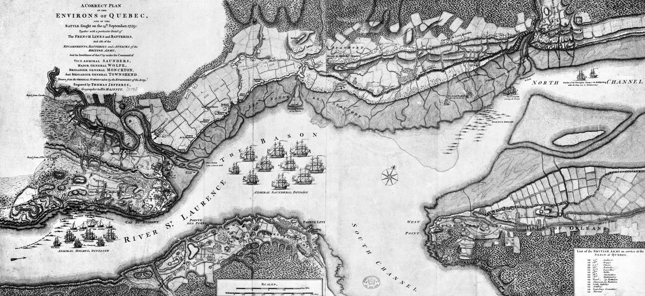
A Correct Plan of the environs of Quebec and of the battle fought on 13th September, 1759 by Thomas Jefferys

A Correct Plan of the environs of Quebec and of the battle fought on 13th September, 1759

(A Correct Plan of the environs of Quebec and of the battle fought on 13th September, 1759 )


Thomas Jefferys

€ 109.35
Enthält 13.5% MwSt.
   Configure art print
1759  ·  engraving  ·  Picture ID: 390776

Nonclassified artists

A Correct Plan of the environs of Quebec and of the battle fought on 13th September, 1759 by Thomas Jefferys. Available as an art print on canvas, photo paper, watercolor board, uncoated paper or Japanese paper.
quebec · canada · 18th century · french · colony · colonial · empire · new france · st lawrence · river · america · north america · fort · settlement · cartography · cartographic · colonies · colonial · battle of quebec · plains of abraham · seven years war · warfare · tactics · tactical · naval · victory · strategy · strategic · plan · battlefield · general wolfe · james wolfe · major general wolfe · vice admiral saunders · brigadier general monckton · brigadier general townshend · battle · army · navy · british · French and Indian War · Private Collection / Bridgeman Images
zu Favoriten hinzufügen   Add to favorites    Select wall color    View painting in a room AR/3D   View in 3D / AR
0 Reviews

Configure art print

Picture Frame

Medium & Stretcher

Glass & Passepartout

Miscellaneous & Extras

 Save / compare configuration
Preview Icon

Summary

Gemälde
Veredelung
Keilrahmen
Museumslizenz

€ 109.35
(inkl. 20% MwSt)
   Add to cart

Bildschärfe: PERFEKT

Should you desire adjustments to brightness and color, or a custom crop of the motif, we are happy to make these changes at no additional cost to you. Please do not hesitate to contact us.

Similar artworks selected for you

The capture of the Prussian fortress of Kolberg on 16 December 1761 Map of the city and environs of Quebec with its siege and blockade by the Americans, illustration from the The Harbour of Cape Cod, from Voyages de Sieur Champlain by Samuel de Champlain, Published in Paris, 1613 Siege of La Rochelle Plan of the Ile d A New and Accurate Plan of the City and Harbour of Cartagena, Showing the Descent of That Place by the British Fleet and Land Forces, Under the Command of the Admirals Vernon and Ogle and General Wentworth in March & April 1741 Map of the Siege of Quebec by the British Fleet, 1670 Naval battle of Saint-Martin-de-Re on 27th October 1622, Ile de Re Map No.10 showing the route of the Armada fleet, engraved by Augustine Ryther The Towne and Platforme of Fayall wonne by the right Honourable Earle of Cumberland, September 2nd 1589 Plan of the Bay and City of Rio de Janeiro and the disposition of the French and Portuguese naval forces during the French attack under Duguay-Trouin in 1711, c.1730 Manche N* 014, Musee d Map of the Naval Battle between the Swedish and Danish Fleets in the Belt, 1644 (Freti Danici Orsundt Accuratissima Delineatio cum Regis Sueciae, Daniae et Hollandia classibg. Ao. 1644) Ostende, from Siege of Krakow (1655) Wolfe Map No.6 showing the route of the Armada fleet, engraved by Augustine Ryther, 1588 Map No.2 Showing the route of the Armada fleet, engraved by Augustine Ryther, 1588 Map of the Battle of Landen The Haven of Brindisi, illustration to Map of St. Petersburg, c.1750 The Capture of Cadiz, 21 June 1596 Plan of the defeat of the American Fleet on Lake Champlain Plan of the Town and the Citadel of Saint-Martin-de-Re, Ile de Re Plan of the Siege of Sebastopol 1854-55, engraved by Robert Walker, pub. William Mackenzie, c.1860 Plan of West Point, the Key Fort that Benedict Arnold Plotted to Deliver to the British During the War of Independence The Capture of Cádiz in 1596 Map of Lake Ontario with the English and French fleets Plan of the Town and Harbour of Cartagena, Colombia
Show more similar artworks

Other art prints by Thomas Jefferys

The West-India Islands, 1794-1801 The Battle of Falkirk, 28 January 1746 Map of Florida The Atlantic or Western Ocean from the West-India Atlas, 1775 View of the Banqueting House and Horse Guards Building in London A Map of Atlantic-Pacific A Map of Nova Scotia The British Virgin Islands (Engraved by Georges-Louis Le Rouge, 1779) A Map of the Most Inhabited Part of New England, Containing the Provinces of Massachusetts Bay and New Hampshire with the Colonies of Connecticut and Rhode Island A Map of South Carolina and a Part of Georgia A Correct Plan of the environs of Quebec and of the battle fought on 13th September, 1759 The Virgin Islands from English and Danish Surveys A Plan of River St. Laurence by Jeffreys Chart of the Atlantic Ocean, with the British, French & Spanish settlements in North America and the West Indies Colour Map of Dominica with Detailed Geographical Observations, c.1760
Discover more works by Thomas Jefferys

Excerpt from our top sellers

The Luncheon: Monet Quince, Cabbage, Melon, and Cucumber, c.1602 Profile Portrait of a Young Woman Landscape on Saint-Martin Island The Sin Pink Peach Trees (Souvenir of Mauve) Poster advertising The Piri Reis World Map, 1513 The Alexander Mosaic, depicting the Battle of Issus between Alexander the Great and Darius III in 333 BC, Roman floor mosaic removed from the Casa del Fauno Woman with a Parasol The Fisherman Landscape from Saint-Rémy Still Life with Coffee Seated Woman with Bent Knees Composition Z VIII
Show More Artworks


What our customers think about us


Frequently Asked Questions about Meisterdrucke


Personalizing your art print at Meisterdrucke is a simple and intuitive process that allows you to design an artwork exactly to your specifications: Choose a frame, determine the image size, decide on a printing medium, and add suitable glazing or a stretcher frame. We also offer customization options such as mats, fillets, and spacers. Our customer service is available to help you design your perfect artwork.

At Meisterdrucke, you have the fascinating option to visualize the artwork you configured directly in your own space. For a tailored preview, simply upload a photo of your room and let the artwork appear on it. If you visit us via a mobile device, be it a phone or tablet, our augmented reality feature brings the image to life and seamlessly projects it into your space. An experience that uniquely combines art and technology.

Choosing the medium is often a matter of personal taste. To give you a clearer idea, we have provided some images for each medium. For a holistic experience, we also offer you a sample set of all paper variants so you can make a decision not just visually but also haptically. You can take advantage of the sample set free of charge – only the shipping costs will apply. You can order the sample set directly.

Do not worry. At Meisterdrucke, we do not proceed mechanically. We manually review each order. If there are any inconsistencies or peculiarities in the configuration, we will immediately contact you. Of course, our courteous and patient support is always at your side to assist you with the configuration. Together with you, we adjust your image by phone or email so that the final result exactly meets your expectations.


Do you have any questions?

Are you interested in an art print from our manufactory but still unsure? Do you need advice on choosing the medium or help with the order?

Our experts are happy to assist you.

+43 4257 29415
support@meisterdrucke.com
Mo-Do: 7:00 - 16:00 | Fr: 7:00 - 13:00

Do you have any questions?

Are you interested in an art print from our manufactory but still unsure? Do you need advice on choosing the medium or help with the order?

Our experts are happy to assist you.

+43 4257 29415
support@meisterdrucke.com
Mo-Do: 7:00 - 16:00 | Fr: 7:00 - 13:00


Meisterdrucke

   Kärntner Strasse 46
        9586 Finkenstein am Faaker See
        Austria
        +43 4257 29415
        support@meisterdrucke.com
Other languages

                   
Erfahrungen & Bewertungen zu Meisterdrucke
Partner Logos

Kaiser Franz Joseph

Meisterdrucke
Kärntner Strasse 46
9586 Finkenstein am Faaker See · Austria
+43 4257 29415 · office@meisterdrucke.com
Partner Logos


(c) 2025 meisterdrucke.ie