support@meisterdrucke.com  ·  0043 4257 29415

Deutsch English Italiano Español Français Nederlands Português Svenska Polski Dansk
Search by artist, work title or style – e.g. Monet, Starry Night, Impressionism, Hokusai wave, nude. Describe the scene – e.g. green meadow, abstract with lots of red, dark oil painting, standing nude next to a tree.

Map of Britain in 665, from

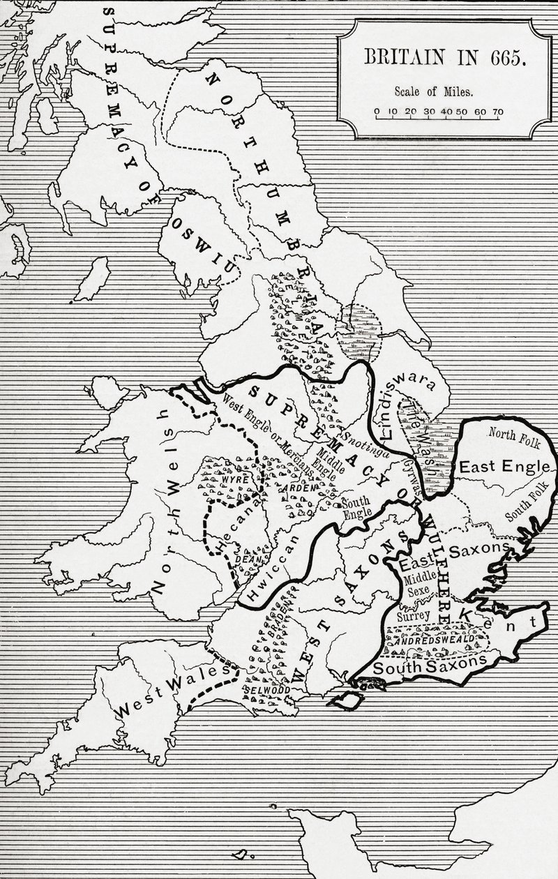
Map of Britain in 665, from 'A Short History of the English People' by J. R. Green, published 1893

(Map of Britain in 665, from The Northumbrian Kingdom 588 to 685 in 'A Short History of the English People' by J. R. Green, published 1893 )


English School

€ 140.94
Enthält 13.5% MwSt.
   Configure art print
1893  ·  lithograph  ·  Image ID: 98558

Cultural Circles  ·  Cartography

Map of Britain in 665, from 'A Short History of the English People' by J. R. Green, published 1893 by English School. Available as an art print on canvas, photo paper, watercolor board, natural paper, or Japanese paper.
cartography · historical · mapping · region · regions · supremacy of wulfhere · county · counties · northumbria · england · scotland · wales · diagram · illustration · c07th · territory · territories · early medieval · anglo-saxon · anglo saxon · british · Private Collection / Bridgeman Images
Other color versions of this image  
AR/3D   View in 3D / AR zu Favoriten hinzufügen   Add to favorites    Change wall color    View picture in a room
0 Reviews

Configure art print

Picture Frame

Medium & Stretcher

Glass & Passepartout

Miscellaneous & Extras

 Save / compare configuration
Preview Icon

Summary

Gemälde
Veredelung
Keilrahmen
Museumslizenz

€ 140.94
(inkl. 20% MwSt)
   Add to cart

Bildschärfe: PERFEKT

If you'd like us to adjust the brightness, colors, or crop the image, we're happy to do this for you at no extra cost. Just get in touch!

Similar artworks selected for you

Map of Britain in 593, printed by Stanfords Geographical Establishment The Northmen in England, 1902 Map illustrating the Welsh wars of William Rufus and Henry I, from Map of the British Isles, 1946 Map of Great Britain showing the dominions of William the Conqueror, c.1087, from Historical Atlas, published 1923 Map of the Wars of the Roses, 15th Century, 1893 England during the Civil War, 1642-1649 The Dominions of the Angevins, 1892 Geographic map of Denmark in 1861, with the Duchies of Schleswig, Holstein and Lauenburg (engraving in Chart of the Spanish Armada Roman Britain, c1920 A map of Stratford-upon-Avon and its surrounding areas, 1610 Map of the Dominions of the Angevins, from A New Map of England Scotland and Wales Map of Ireland in the sixth century, from the book Britania Insula quae dup Regna continet Angliam et Scotiam cum Hibernia adiacente, engraved by Paulo Forlani, 1562 Map of the British Isles, 1910 Ireland Just Before the English Norman Invasion, 1169 New England in 1660, c1880 Map of the Vikings & Western Christendom in the Ninth Century Chart of the Spanish Armada Map of England and Wales London Midland and Scottish Railway
Show more similar artworks

Similar artworks selected for you

Map of Britain in 593, printed by Stanfords Geographical Establishment The Northmen in England, 1902 Map illustrating the Welsh wars of William Rufus and Henry I, from Map of the British Isles, 1946 Map of Great Britain showing the dominions of William the Conqueror, c.1087, from Historical Atlas, published 1923 Map of the Wars of the Roses, 15th Century, 1893 England during the Civil War, 1642-1649 The Dominions of the Angevins, 1892 Geographic map of Denmark in 1861, with the Duchies of Schleswig, Holstein and Lauenburg (engraving in Chart of the Spanish Armada Roman Britain, c1920 A map of Stratford-upon-Avon and its surrounding areas, 1610 Map of the Dominions of the Angevins, from A New Map of England Scotland and Wales Map of Ireland in the sixth century, from the book Britania Insula quae dup Regna continet Angliam et Scotiam cum Hibernia adiacente, engraved by Paulo Forlani, 1562 Map of the British Isles, 1910 Ireland Just Before the English Norman Invasion, 1169 New England in 1660, c1880 Map of the Vikings & Western Christendom in the Ninth Century Chart of the Spanish Armada Map of England and Wales London Midland and Scottish Railway
Show more similar artworks

More art prints by English School

Church and Cottage with Lighted Windows The Portrait of King Richard III Kidbrooke Park, Kent, formerly attributed to George Lambert (1700-65) c.1740-50 Portrait of a bodybuilder, c. 1898 Poster advertising ‘A Midsummer Night Detailed Map of Gallipoli Peninsula and the Dardanelles, Turkey, 1915, from Romeo buys poison from the apothecary, illustration from Romeo and Juliet, from "The Illustrated Library Shakespeare", published in London 1890 An Allegory of the Tudor Succession: The Family of Henry VIII, c. 1589-95 Scorpion Fish, plate 8 from “The Zoology of the Voyage of H.M.S Beagle, 1832-36” by Charles Darwin Improved Map of India, published in London 1820 ‘Cunard Line - Monarchs of the Sea’, poster for the Lusitania and Mauretania Buddhist domestic altar, from Map of Ireland from The Mountains of Ararat, or The Manner how the Whole Earth was Peopled by Noah and his Descendants after the Flood, engraved for the
Show more works by English School

More art prints by English School

Church and Cottage with Lighted Windows The Portrait of King Richard III Kidbrooke Park, Kent, formerly attributed to George Lambert (1700-65) c.1740-50 Portrait of a bodybuilder, c. 1898 Poster advertising ‘A Midsummer Night Detailed Map of Gallipoli Peninsula and the Dardanelles, Turkey, 1915, from Romeo buys poison from the apothecary, illustration from Romeo and Juliet, from "The Illustrated Library Shakespeare", published in London 1890 An Allegory of the Tudor Succession: The Family of Henry VIII, c. 1589-95 Scorpion Fish, plate 8 from “The Zoology of the Voyage of H.M.S Beagle, 1832-36” by Charles Darwin Improved Map of India, published in London 1820 ‘Cunard Line - Monarchs of the Sea’, poster for the Lusitania and Mauretania Buddhist domestic altar, from Map of Ireland from The Mountains of Ararat, or The Manner how the Whole Earth was Peopled by Noah and his Descendants after the Flood, engraved for the
Show more works by English School

More motifs from the category Cartography

Map of England, Britannia Antiqua, from “The Atlas of Ancient Geography” by Samuel Butler, published in London, c. 1829 Partial Map of the Middle East in the 1890s, from "The Citizen Map of the County of Philadelphia from Actual Survey, 1843 Map of the route followed by Hernando Cortés (1485-1547) during the conquest of Mexico Map of the United States in 1803, from Scott Map of Paris at the Outbreak of the French Revolution, 1789, published by William Blackwood and Sons, Edinburgh and London, 1848 Map of Southern Britain, Coloured to Show Geological Areas of Interest, Annotated by William Smith Maps of Holy Island and Farne Island, Northumberland, from Straits of Gibraltar to Alicante as far inland as the Guadalquivir valley and Seville and the coast of North Africa, in Map of Lotharingia, from Map of the Kingdom of Great Britain and Ireland, 1610 Mount Sinai and the Red Sea, from an Atlas of the World in 33 Maps, Venice, 1st September 1553 (detail from 330963) Map of Surrey, described and divided into hundreds Map of Aurelia, from
View More from "Cartography"

More motifs from the category Cartography

Map of England, Britannia Antiqua, from “The Atlas of Ancient Geography” by Samuel Butler, published in London, c. 1829 Partial Map of the Middle East in the 1890s, from "The Citizen Map of the County of Philadelphia from Actual Survey, 1843 Map of the route followed by Hernando Cortés (1485-1547) during the conquest of Mexico Map of the United States in 1803, from Scott Map of Paris at the Outbreak of the French Revolution, 1789, published by William Blackwood and Sons, Edinburgh and London, 1848 Map of Southern Britain, Coloured to Show Geological Areas of Interest, Annotated by William Smith Maps of Holy Island and Farne Island, Northumberland, from Straits of Gibraltar to Alicante as far inland as the Guadalquivir valley and Seville and the coast of North Africa, in Map of Lotharingia, from Map of the Kingdom of Great Britain and Ireland, 1610 Mount Sinai and the Red Sea, from an Atlas of the World in 33 Maps, Venice, 1st September 1553 (detail from 330963) Map of Surrey, described and divided into hundreds Map of Aurelia, from
View More from "Cartography"

A selection of our top sellers

The Munnekeholm with the Aduardergasthuis in the foreground and the West-Indisch Huis in the background Fruit Trees, 1901 Composition, 1930 The Symphony of the Cat, drawing by Moritz von Schwind of 1868. Staatliche Kunsthalle Karlsruhe. The Kiss, 1907-08 Self-Portrait in a Fur Coat The Yellow Books, 1887 Lisbeth Winter Landscape with Skaters and a Bird Trap, 1565 Turkish Café The landscape and her children The Interior of the Palm House, 1832-1833 Lilith View of Kairouan The Harvesters, 1565
Show more artworks

A selection of our top sellers

The Munnekeholm with the Aduardergasthuis in the foreground and the West-Indisch Huis in the background Fruit Trees, 1901 Composition, 1930 The Symphony of the Cat, drawing by Moritz von Schwind of 1868. Staatliche Kunsthalle Karlsruhe. The Kiss, 1907-08 Self-Portrait in a Fur Coat The Yellow Books, 1887 Lisbeth Winter Landscape with Skaters and a Bird Trap, 1565 Turkish Café The landscape and her children The Interior of the Palm House, 1832-1833 Lilith View of Kairouan The Harvesters, 1565
Show more artworks


What our customers think about us


Frequently Asked Questions about Meisterdrucke


Personalizing your art print at Meisterdrucke is simple and intuitive: Choose a frame, set the image size, pick a printing medium, and add suitable glazing or a stretcher frame. We also offer additional customization options like mats, fillets, and spacers. If you have any questions, our customer service team is ready to help you create your perfect artwork.

At Meisterdrucke, you can visualize your configured artwork directly in your own room. Simply upload a photo of your space and see how the artwork looks in it. If you're visiting us on a mobile device — phone or tablet — our augmented reality feature brings the picture to life and projects it right into your room. A unique experience that combines art and technology.

Choosing the right medium is often a matter of personal taste. To give you a better idea, we've provided some images for each medium. We also offer a sample set of all paper variants, so you can decide not just visually but by touch as well. You can order the sample set free of charge — only shipping costs apply.

Don't worry! At Meisterdrucke, we don't just process orders mechanically. Every order is manually reviewed by our team. If we spot any inconsistencies or issues with your configuration, we'll get in touch with you right away. And of course, our friendly and patient support team is always here to help you with your configuration. We'll work with you by phone or email to adjust your image so the final result is exactly what you had in mind.


Still have questions?

Are you interested in an art print from our manufactory but still unsure? Do you need advice on choosing the medium or help with the order?

Our experts are happy to assist you.

+43 4257 29415
support@meisterdrucke.com
Mo-Do: 7:00 - 16:00 | Fr: 7:00 - 13:00

Still have questions?

Are you interested in an art print from our manufactory but still unsure? Do you need advice on choosing the medium or help with the order?

Our experts are happy to assist you.

+43 4257 29415
support@meisterdrucke.com
Mo-Do: 7:00 - 16:00 | Fr: 7:00 - 13:00


Meisterdrucke

   Kärntner Strasse 46
        9586 Finkenstein am Faaker See
        Austria
        +43 4257 29415
        support@meisterdrucke.com
Other languages

                   
Erfahrungen & Bewertungen zu Meisterdrucke
Post.at DHL Express Quehenberger Cargoboard
Kaiser Franz Joseph

Meisterdrucke
Kärntner Strasse 46
9586 Finkenstein am Faaker See · Austria
+43 4257 29415 · support@meisterdrucke.com
Post.at DHL Express Quehenberger Cargoboard


(c) 2026 meisterdrucke.ie