support@meisterdrucke.com  ·  0043 4257 29415

Deutsch English Italiano Español Français Nederlands Português Svenska Polski Dansk
Search by artist, work title or style – e.g. Monet, Starry Night, Impressionism, Hokusai wave, nude. Describe the scene – e.g. green meadow, abstract with lots of red, dark oil painting, standing nude next to a tree.

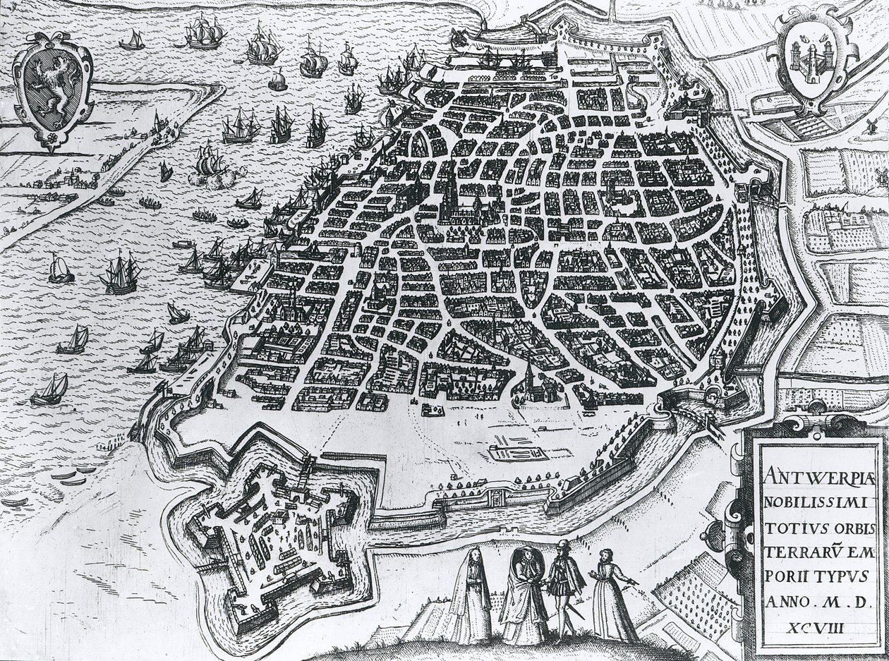
Map of Antwerp, 1598 by Dutch School

Map of Antwerp, 1598

(Map of Antwerp, 1598 )


Dutch School

€ 144.19
Includes 13.5% VAT
   Configure art print
1598  ·  engraving  ·  Image ID: 82630

Cultural Circles  ·  Cartography

Map of Antwerp, 1598 by Dutch School. Available as an art print on canvas, photo paper, watercolor board, natural paper, or Japanese paper.
view from the south · fortified · walled · harbour · fortification · coastline · ship · plan · belgium · anvers · port · river scheldt · birds eye view · Private Collection / Bridgeman Images
Other color versions of this image  
AR/3D   View in 3D / AR zu Favoriten hinzufügen   Add to favorites    Change wall color    View picture in a room
0 Reviews

Configure art print

Picture Frame

Medium & Stretcher

Glass & Passepartout

Miscellaneous & Extras

 Save / compare configuration
Preview Icon

Summary

Gemälde
Veredelung
Keilrahmen
Museumslizenz

€ 144.19
(inkl. 20% MwSt)
   Add to cart

Bildschärfe: PERFEKT

If you'd like us to adjust the brightness, colors, or crop the image, we're happy to do this for you at no extra cost. Just get in touch!

Similar artworks selected for you

View of Antwerp Plan of Antwerp Antwerp, Belgium City Map of Moscow in the 17th Century. Map of Antwerp, from Map of Antwerp, from Ancona, Italy Map of Alexandria, Egypt Plan of Ancona (Ancona), Italy Algiers, Algeria View of Algiers, Algeria Town Map of Alexandria in Egypt, c.1625 City of Antwerp City Map of Milan, 1572 Map of Ancona City of Quinsai, Engraving from La Cosmographie Universelle by Andre Thevet Map of Messina, from Chief Town of the Celtic Group Bituriges Vivisci, Bordeaux, France Algiers, Algeria Staden, Germany - in Map of Palermo, from Palermo, Italy (engraving) Middle Ages: aerial view of the city of Lübeck in Germany with street map, showing its geographic position on an island at the confluence of the Wakenitz and Trave rivers. 15th century. Germany. Illustration by Giorgio Albertini. (The use of this author Map of Padua, from "Les Villes de Venétie", 1704, published by Pierre Mortier in Amsterdam Stade Located on the Lower Elbe River, Germany (engraving) Plan of La Rochelle, France Map of Algiers from Emden, Germany
Show more similar artworks

More art prints by Dutch School

Map of New Holland, now Australia, and of New Zealand, drawn from information collected during trips undertaken by Abel Janszoon Tasman (1603-1659) and Willem Janszoon (1570-1630) Terrarum Orbis Tabula, after G. a Schagen. Published c. 1689 Stellatum Planisphaerium, a planisphere with signs of the Zodiac Plaque with a Chinoiserie Landscape and Gilt Details, c. 1680 Martin Luther Preaching, detail from the altarpiece of the Church of Torslunde A Dodo Sint Eustatius in the Dutch Antilles, with West Indiamen Massed in the Road off Oranjestad Rock the Brazilian Miracle of Our Lady of Nazaré. Our Lady of Nazaré Church (Largo Nossa Senhora da Nazaré). Portugal. Map of the Magellan Straits, Patagonia Map of Greece, Hungary and their surrounding countries Map of the Cape of Good Hope. Table Bay, South Africa. King Alvaro I of Kongo receiving the Dutch ambassadors, an illustration from the The Coronation of William of Orange (1650-1702) and Mary (1662-94), at Westminster Abbey, 21st April 1689 Compass Rose, from a Blue Atlas, published in Amsterdam, 1697
Show more works by Dutch School

More motifs from the category Cartography

Map of South Pacific Island Map of Genoa and Florence, from Map of Orléans and Bourges, from „Civitates Orbis Terrarum“ by Georg Braun (1541-1622) and Frans Hogenberg (1535-90), c. 1572 Map of the Battles of Smolensk and Valtellina, published by William Blackwood and Sons, Edinburgh and London, 1848 French school textbook map of Indochina, 1905 Map of Paris c.1540, known as the Plan de la Tapisserie, made as a tapestry c.1571, 1818 Map of the city of Siam, capital of the kingdom of that name after a survey done by a French engineer in 1687, published in the 1751 edition of Histoire Générale des Voyages by Antoine Prévost Map of Central and South America, from Map of the world in the form of a globe, miniature from Grandes Chroniques de Philippe le Hardi Map of the West Indies, Florida and South America A Map of the West End and Soho, London, 1746 Battle of Waterloo, Map of the Battlefield, engraved by Jacowick, 1816 Map of Central and North America, published in 1700, Paris A Map of Mile End and Stepney Green, London, 1746 A new and accurate map of the world, 1676
View More from "Cartography"

A selection of our top sellers

Nude in an Interior Nymphs and Satyr Raven on a Birch Tree Seated Woman with Raised Knee Saint Michael the Archangel, ca 1663 Atlantic Roll, 1895 The Fox, 1913 Still Life with Coffee Garden in Giverny The Blue Room Roe Deer and Landscape After the Ball Noonday Heat The Langlois Bridge at Arles with Washerwomen Sunset on the Seine at Lavacourt, Winter Effect
Show more artworks


What our customers think about us


Frequently Asked Questions about Meisterdrucke


Personalizing your art print at Meisterdrucke is simple and intuitive: Choose a frame, set the image size, pick a printing medium, and add suitable glazing or a stretcher frame. We also offer additional customization options like mats, fillets, and spacers. If you have any questions, our customer service team is ready to help you create your perfect artwork.

At Meisterdrucke, you can visualize your configured artwork directly in your own room. Simply upload a photo of your space and see how the artwork looks in it. If you're visiting us on a mobile device — phone or tablet — our augmented reality feature brings the picture to life and projects it right into your room. A unique experience that combines art and technology.

Choosing the right medium is often a matter of personal taste. To give you a better idea, we've provided some images for each medium. We also offer a sample set of all paper variants, so you can decide not just visually but by touch as well. You can order the sample set free of charge — only shipping costs apply.

Don't worry! At Meisterdrucke, we don't just process orders mechanically. Every order is manually reviewed by our team. If we spot any inconsistencies or issues with your configuration, we'll get in touch with you right away. And of course, our friendly and patient support team is always here to help you with your configuration. We'll work with you by phone or email to adjust your image so the final result is exactly what you had in mind.


Still have questions?

Are you interested in an art print from our manufactory but still unsure? Do you need advice on choosing the medium or help with the order?

Our experts are happy to assist you.

+43 4257 29415
support@meisterdrucke.com
Mo-Do: 7:00 - 16:00 | Fr: 7:00 - 13:00

Still have questions?

Are you interested in an art print from our manufactory but still unsure? Do you need advice on choosing the medium or help with the order?

Our experts are happy to assist you.

+43 4257 29415
support@meisterdrucke.com
Mo-Do: 7:00 - 16:00 | Fr: 7:00 - 13:00


Meisterdrucke

   Kärntner Strasse 46
        9586 Finkenstein am Faaker See
        Austria
        +43 4257 29415
        support@meisterdrucke.com
Other languages

                   
Erfahrungen & Bewertungen zu Meisterdrucke
Post.at DHL Express Quehenberger Cargoboard
Kaiser Franz Joseph

Meisterdrucke
Kärntner Strasse 46
9586 Finkenstein am Faaker See · Austria
+43 4257 29415 · support@meisterdrucke.com
Post.at DHL Express Quehenberger Cargoboard


(c) 2026 meisterdrucke.ie