Search by artist, work title or style – e.g. Monet, Starry Night, Impressionism, Hokusai wave, nude. Describe the scene – e.g. green meadow, abstract with lots of red, dark oil painting, standing nude next to a tree.

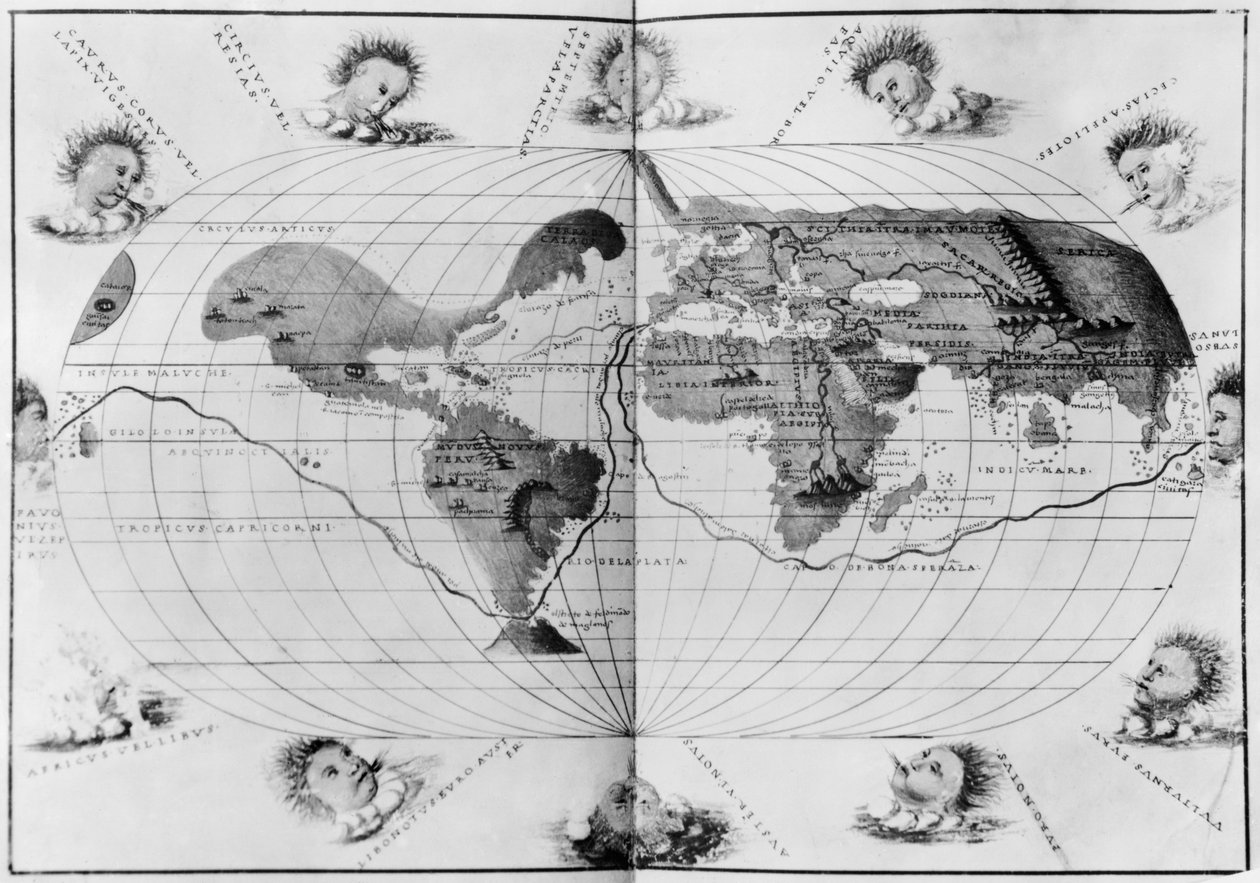
World map tracing Magellan

World map tracing Magellan's world voyage, from the 'Portolan Atlas of the World', c.1540

(World map tracing Magellan's world voyage, from the 'Portolan Atlas of the World', c.1540 (see also 63417, 151822) )


Battista Agnese

€ 146.46
Enthält 13.5% MwSt.
   Configure art print
Undated  ·  Gravur  ·  Picture ID: 105531

Nonclassified artists  ·  Cartography

World map tracing Magellan's world voyage, from the 'Portolan Atlas of the World', c.1540 by Battista Agnese. Available as an art print on canvas, photo paper, watercolor board, uncoated paper or Japanese paper.
cherub · cherubs · new world · winds · wind · blowing · exploration · Bibliotheque Nationale, Paris, France / Bridgeman Images
AR/3D   View in 3D / AR zu Favoriten hinzufügen   Add to favorites    Select wall color    View painting in a room
0 Reviews

Configure art print

Picture Frame

Medium & Stretcher

Glass & Passepartout

Miscellaneous & Extras

 Save / compare configuration
Preview Icon

Summary

Gemälde
Veredelung
Keilrahmen
Museumslizenz

€ 146.46
(inkl. 20% MwSt)
   Add to cart

Bildschärfe: PERFEKT

Should you desire adjustments to brightness and color, or a custom crop of the motif, we are happy to make these changes at no additional cost to you. Please do not hesitate to contact us.

Similar artworks selected for you

Map of Magellan Oval Planisphere of the World Showing Magellan Ptolemy of Alexandria A general chart for the purpose of picking off a ship World Map of Johannes Stabius Planisphere (or World Map) Geographic Chart of the World After the Deluge Map of the New World 1587 This is Probably the Earliest Perspective Representation of the Earth as a Globe World Map of Johannes Stabius Johannes Stabius Map of the World, 1515 Map of North America Early 17th Century Map of the World, After Mercator, with Inset Portraits of Explorers (Drake, Magellan, Thomas Cavendish and Oliver van der Nort), the Elements, and Eclipses Map of Magellan Map of the northern hemisphere A General Map, from Magnetic Map of the Earth World Map World Map in a Double Hemisphere World Map or General Map of the Earth The Curious Atlas or the World Represented in General and Particular Maps of the Sky and Earth, p. 18 Map of Rome Map Showing Drake Nova Orbis Terrarum, from "Tabulae Rudolphinae" by Johannes Kepler Geography diagram, from The Gentlemans Recreation published by Richard Blome Map of the World, According to Ptolemy, 1923 Map of North America, 1747 World Map; Vera Totius Expeditionis Nauticae, charting the circumnavigation of the globe by Sir Francis Drake and Thomas Cavendish c.1595 Typus Orbis Terrarum, World Map, 1577
Show more similar artworks

Other art prints by Battista Agnese

Zodiac Calendar, from an Atlas of the World in 33 Maps, Venice, 1st September 1553 Map tracing Magellan The Continent of Europe, from an Atlas of the World in 33 Maps, Venice, 1st September 1553 The Indian Ocean, from an Atlas of the World in 33 Maps, Venice The New World, from an Atlas of the World in 33 Maps, Venice, 1st September 1553 Mount Sinai and the Red Sea, from an Atlas of the World in 33 Maps, Venice, 1st September 1553 (detail) Map of Magellan The Continent of Africa, from an Atlas of the World in 33 Maps, Venice, 1st September 1553 Map of the Black Sea Including Part of Present-Day Romania, Bulgaria, Turkey, Ukraine, and Russia Moschoviae Tabula, Map of Russia and European Cities along the Volga River Ethiopia, the Red Sea and Saudi Arabia, from an Atlas of the World in 33 Maps, Venice, 1st September 1553 (Detail) World map tracing Magellan A Double-Page Map of the Atlantic Ocean, Showing the East Coast of North and South America The Pacific Ocean, from an Atlas of the World in 33 Maps, Venice, 1st September 1553 Holy Land, Israel and Palestine: Sea of Galilee and City of Tiberias, from Atlas of the World in Thirty-Three Maps, by Battista Agnese
Discover more works by Battista Agnese

Other motives from the category Cartography

A Map of Samaria, from Map of Europe at the Time of the Third Crusade, 1190, from Map of the City of New York [as far north as East 53rd Street], 1885 Insurance Map of the City of Philadelphia; volume 2, plate15, 1887 Map of part of Bas-Poitou and the Ile de Noirmoutier, 1703 Map of Spain and Portugal, from Map of the Island of Puerto Rico, 1599 Map of the St. Lawrence Estuary Map of Canada from Map of the Mediterranean, 1625 Map of the Ottoman Empire, from the Map of Treviso, from Map of the Battles of Turcoing and Tournay, Published by William Blackwood and Sons Map of Poznan and Gruczno, from Map of the Battle of Montmirail, published by William Blackwood and Sons, Edinburgh and London, 1848
View More from "Cartography"

Excerpt from our top sellers

Self-Portrait at a Young Age The Lady of Shalott Colored Leaves at Kaianji Temple Stag Beetle The Cactus Friend Still Life with Coffee Sunset on the Seine at Lavacourt, Winter Effect Midsummer Eve The Carpet Merchant Flute Concert with Frederick the Great in Sanssouci, 1850-1852 The Fourth Estate Irises Narcissus Boy with a Crow The Water Lily Pond, Green Reflections
Show More Artworks


What our customers think about us


Frequently Asked Questions about Meisterdrucke


Personalizing your art print at Meisterdrucke is a simple and intuitive process that allows you to design an artwork exactly to your specifications: Choose a frame, determine the image size, decide on a printing medium, and add suitable glazing or a stretcher frame. We also offer customization options such as mats, fillets, and spacers. Our customer service is available to help you design your perfect artwork.

At Meisterdrucke, you have the fascinating option to visualize the artwork you configured directly in your own space. For a tailored preview, simply upload a photo of your room and let the artwork appear on it. If you visit us via a mobile device, be it a phone or tablet, our augmented reality feature brings the image to life and seamlessly projects it into your space. An experience that uniquely combines art and technology.

Choosing the medium is often a matter of personal taste. To give you a clearer idea, we have provided some images for each medium. For a holistic experience, we also offer you a sample set of all paper variants so you can make a decision not just visually but also haptically. You can take advantage of the sample set free of charge – only the shipping costs will apply. You can order the sample set directly.

Do not worry. At Meisterdrucke, we do not proceed mechanically. We manually review each order. If there are any inconsistencies or peculiarities in the configuration, we will immediately contact you. Of course, our courteous and patient support is always at your side to assist you with the configuration. Together with you, we adjust your image by phone or email so that the final result exactly meets your expectations.


Do you have any questions?

Are you interested in an art print from our manufactory but still unsure? Do you need advice on choosing the medium or help with the order?

Our experts are happy to assist you.

+43 4257 29415
support@meisterdrucke.com
Mo-Do: 7:00 - 16:00 | Fr: 7:00 - 13:00

Do you have any questions?

Are you interested in an art print from our manufactory but still unsure? Do you need advice on choosing the medium or help with the order?

Our experts are happy to assist you.

+43 4257 29415
support@meisterdrucke.com
Mo-Do: 7:00 - 16:00 | Fr: 7:00 - 13:00


Meisterdrucke

   Kärntner Strasse 46
        9586 Finkenstein am Faaker See
        Austria
        +43 4257 29415
        support@meisterdrucke.com
Other languages

                   
Erfahrungen & Bewertungen zu Meisterdrucke
Post.at DHL Express Quehenberger Cargoboard
Kaiser Franz Joseph

Meisterdrucke
Kärntner Strasse 46
9586 Finkenstein am Faaker See · Austria
+43 4257 29415 · office@meisterdrucke.com
Post.at DHL Express Quehenberger Cargoboard


Meisterdrucke 2752 Bewertungen auf ProvenExpert.com

(c) 2025 meisterdrucke.ie