support@meisterdrucke.com  ·  0043 4257 29415

Deutsch English Italiano Español Français Nederlands Português Svenska Polski Dansk
Search by artist, work title or style – e.g. Monet, Starry Night, Impressionism, Hokusai wave, nude. Describe the scene – e.g. green meadow, abstract with lots of red, dark oil painting, standing nude next to a tree.

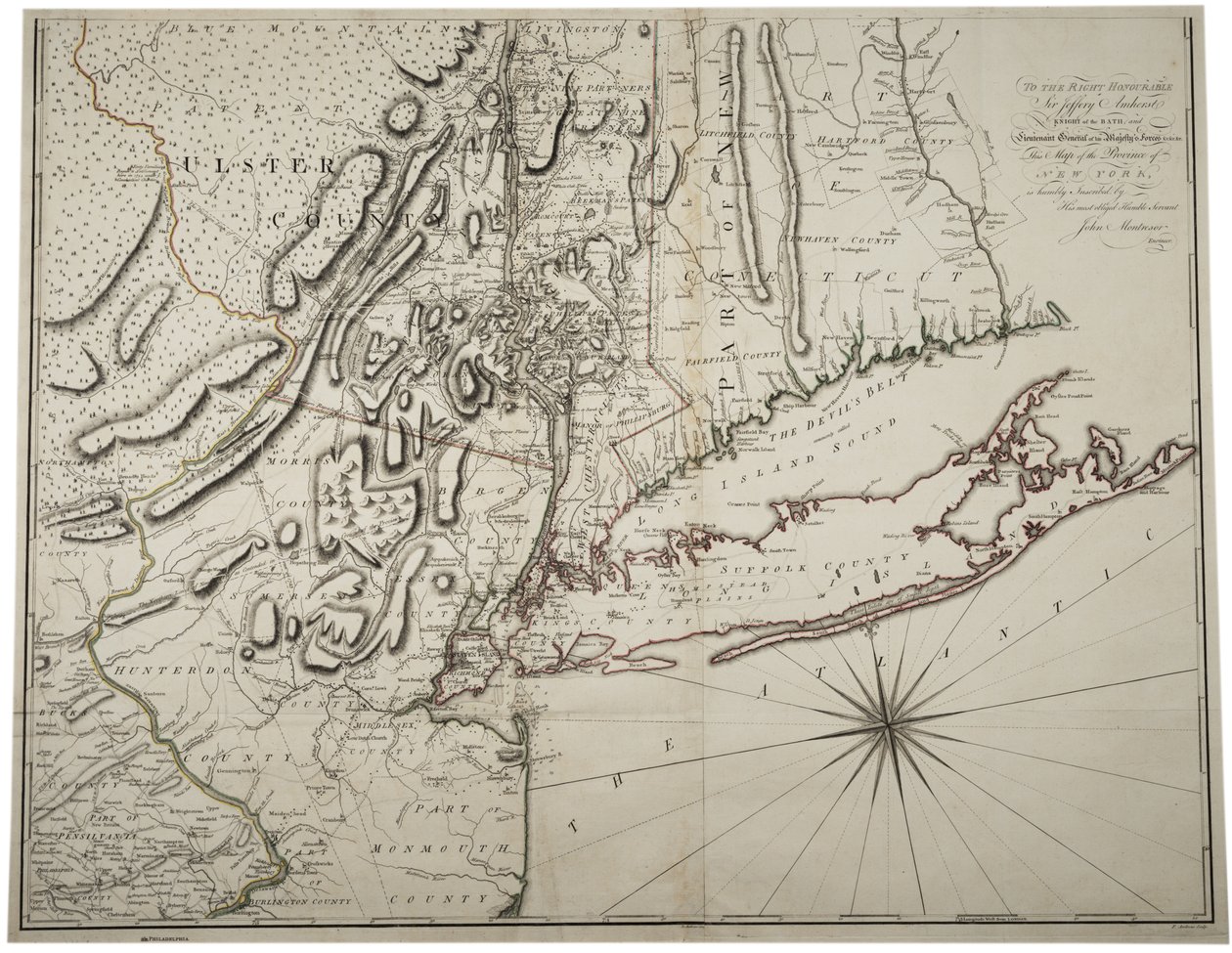
Map of Lower New York State and surrounding areas, c.1775 by John Montresor

Map of Lower New York State and surrounding areas, c.1775

(Map of Lower New York State and surrounding areas, c.1775 )


John Montresor

€ 141.55
Includes 13.5% VAT
   Configure art print
1775  ·  lithograph  ·  Image ID: 234900

Nonclassified artists  ·  Cartography

Map of Lower New York State and surrounding areas, c.1775 by John Montresor. Available as an art print on canvas, photo paper, watercolor board, natural paper, or Japanese paper.
ulster county · monmouth county · hunterdon county · new york · new york city · united states of america · mapping · cartography · maps · c18th · c19th · survey · The War for Independence · American Revolution · Eastern coast · Gilder Lehrman Collection, New York, USA / Bridgeman Images
AR/3D   View in 3D / AR zu Favoriten hinzufügen   Add to favorites    Change wall color    View picture in a room
0 Reviews

Configure art print

Picture Frame

Medium & Stretcher

Glass & Passepartout

Miscellaneous & Extras

 Save / compare configuration
Preview Icon

Summary

Gemälde
Veredelung
Keilrahmen
Museumslizenz

€ 141.55
(inkl. 20% MwSt)
   Add to cart

Bildschärfe: PERFEKT

If you'd like us to adjust the brightness, colors, or crop the image, we're happy to do this for you at no extra cost. Just get in touch!

Similar artworks selected for you

Acadia, the Provinces of Sagadahoc and Maine, New Hampshire, Rhode Island and Part of Massachusetts and Connecticut, Engraving by G. Zuliani A Map of the Province of New York by Captain Montresor Map of New York Island with the adjacent rocks and other remarkable parts of Hell-Gate Plan of the City of New York in North America Surveyed in the Years 1766 and 1767 Published in Faden The City of New York as Laid Out by the Commissioners with the Surrounding Country A Map of New York A Plan of New York Island A map of New England and New York from John Speed A map of the State of New York A chart of the bay and harbour of Pensacola in the province of West Florida A General Map of the Middle British Colonies in America; viz. Virginia, Maryland, Delaware, Pennsylvania, New Jersey, New York, Connecticut, and Rhode Island: of Aquanishuonigy, the Country of the Confederate Indians... Of the Lakes Erie, Ontario and Ch Map of New England and Northern Chesapeake Region The City of New York, as Laid Out by the Commissioners with the Surrounding Country, by Their Secretary and Surveyor John Randel, Jr., 1814 A Map of the Province of New York, with Part of Pennsylvania, and New England Map of the City of New York as Laid Out by the Commissioners, 1814 Icon Sinus Baiarum Pennsylvania, New York, southern New Jersey, with the western part of Connecticut, Massachusetts Bay and Land of the Iroquois, engraving by G. Zuliani taken from Tome I of the A Chart of the Gulf Stream, in Map of The British Governments in North America, engraved by J. Gibson Totius Neobelgii Nova et Accuratissima Tabula, 1674 A Map of the British and French Dominions in North America A Map of the Most Inhabited Part of New England, Containing the Provinces of Massachusetts Bay and New Hampshire with the Colonies of Connecticut and Rhode Island The Seat of War The Atlantic Neptune, Published for the Use of the Royal Navy of Great Britain Hydrographic chart of the Bay of Cadiz The Velasco Map, facsimile, 1610 A Topographical Chart of Rhode Island An Account of the New Northern Archipelago Lately Discovered by the Russians Coast of New England from Cape Elizabeth, Me. to Newburyport, Mass.
Show more similar artworks

More art prints by John Montresor

A Map of the Province of New York with Part of Pennsylvania and New England, from an Actual Survey by Captain Montrésor, Engineer, 1775, 10 June 1775 Map of Lower New York State and surrounding areas, c.1775 Plan of the Disposition of British Troops, with Fortifications North of Fort Knipehausen to Fort Independence Map of the Ohio River from Fort Pitt A Plan of the City of New York and Its Environs to Greenwich on the North (Hudson) River to Crown Point on the East River, Surveyed 1766, 1775 Early Survey of the City of New York and Its Environs to Greenwich, 1766 Battle of Brandywine, 11 September 1777 A Sketch of the Battle of Germantown, 4th October 1777, where the Rebels were Repulsed Battle of Brandywine, 11th September 1777 Gov. Tryon A Map of New York A Map of Boston Map of Boston and Charlestown Copy of a Sketch of the Monongahela, with the Field of Battle
Show more works by John Montresor

More motifs from the category Cartography

Map of India, published by William Blackwood and Sons, Edinburgh and London, 1848 Map of Sixteenth Century Britain and Northern France, from the Map of Africa, published in 1700, Paris Map of the Battle of Talavera, published by William Blackwood and Sons, Edinburgh and London, 1848 (hand-coloured engraving) Map of the Great Lakes An Arab Trader on a Camel, detail from a Renaissance map of Europe, after Jacopo Russo, 1528 Map of Cumberland Map of the Siege of Sebastopol, 18th June 1855, 1855 The Travellers Pocket Map of Louisiana Antiquae Urbis Perfecta Imago, Map of Rome, c. 1600 Map of Brobdingnag, illustration from the first edition of Map of Spain and Portugal showing the political divisions in the country at the death of Alfonso III, King of Leon, from Map of Britain in 792, from Map of New Belgium with a View of New Amsterdam, compiled by Nicolaes Visscher (1618-1709), c. 1651-55 Fol. 16 Map of Persia, Arabia and India, from an atlas, 1571
View More from "Cartography"

A selection of our top sellers

Waterlilies, Evening Ulysses and the Sirens The Tropics, 1910 Composition VIII Sin Saviour. From the Deesis tier Ad Parnassum After a Gale, 1903 Sunny Path The Great Piece of Turf, 1503 Starry Night Old Woman and Boy with Candles, c. 1616-1617 View of L Mountain farmers mowing Beef: diagram depicting the different cuts of meat
Show more artworks


What our customers think about us


Frequently Asked Questions about Meisterdrucke


Personalizing your art print at Meisterdrucke is simple and intuitive: Choose a frame, set the image size, pick a printing medium, and add suitable glazing or a stretcher frame. We also offer additional customization options like mats, fillets, and spacers. If you have any questions, our customer service team is ready to help you create your perfect artwork.

At Meisterdrucke, you can visualize your configured artwork directly in your own room. Simply upload a photo of your space and see how the artwork looks in it. If you're visiting us on a mobile device — phone or tablet — our augmented reality feature brings the picture to life and projects it right into your room. A unique experience that combines art and technology.

Choosing the right medium is often a matter of personal taste. To give you a better idea, we've provided some images for each medium. We also offer a sample set of all paper variants, so you can decide not just visually but by touch as well. You can order the sample set free of charge — only shipping costs apply.

Don't worry! At Meisterdrucke, we don't just process orders mechanically. Every order is manually reviewed by our team. If we spot any inconsistencies or issues with your configuration, we'll get in touch with you right away. And of course, our friendly and patient support team is always here to help you with your configuration. We'll work with you by phone or email to adjust your image so the final result is exactly what you had in mind.


Still have questions?

Are you interested in an art print from our manufactory but still unsure? Do you need advice on choosing the medium or help with the order?

Our experts are happy to assist you.

+43 4257 29415
support@meisterdrucke.com
Mo-Do: 7:00 - 16:00 | Fr: 7:00 - 13:00

Still have questions?

Are you interested in an art print from our manufactory but still unsure? Do you need advice on choosing the medium or help with the order?

Our experts are happy to assist you.

+43 4257 29415
support@meisterdrucke.com
Mo-Do: 7:00 - 16:00 | Fr: 7:00 - 13:00


Meisterdrucke

   Kärntner Strasse 46
        9586 Finkenstein am Faaker See
        Austria
        +43 4257 29415
        support@meisterdrucke.com
Other languages

                   
Erfahrungen & Bewertungen zu Meisterdrucke
Post.at DHL Express Quehenberger Cargoboard
Kaiser Franz Joseph

Meisterdrucke
Kärntner Strasse 46
9586 Finkenstein am Faaker See · Austria
+43 4257 29415 · support@meisterdrucke.com
Post.at DHL Express Quehenberger Cargoboard


(c) 2026 meisterdrucke.ie