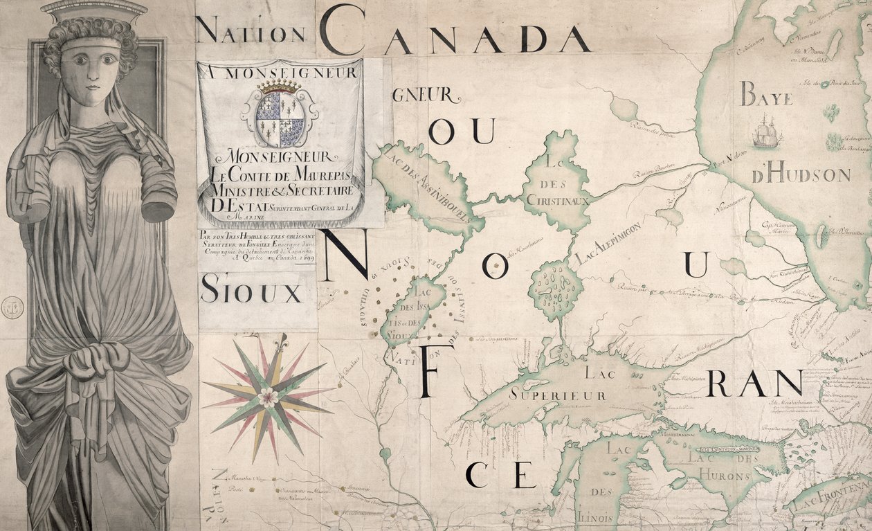
Map of Nouvelle-France (Canada) 1699 by Fonville

Map of Nouvelle-France (Canada) 1699

(Map of Nouvelle-France (Canada) 1699 (see also 159120))


Fonville

€ 127.43
Enthält 13.5% MwSt.
   Configure art print
1699  ·  Gravur  ·  Picture ID: 58349

Nonclassified artists  ·  Cartography

Map of Nouvelle-France (Canada) 1699 by Fonville. Available as an art print on canvas, photo paper, watercolor board, uncoated paper or Japanese paper.
carte · plan · chart · new france · canadian · lake · caryatid · compass · huron · superior · hudson bay · french territory · colony · Service Historique de la Marine, Vincennes, France / Bridgeman Images
zu Favoriten hinzufügen   Add to favorites    Select wall color    View painting in a room AR/3D   View in 3D / AR
0 Reviews

Configure art print

Picture Frame

Medium & Stretcher

Glass & Passepartout

Miscellaneous & Extras

 Save / compare configuration
Preview Icon

Summary

Gemälde
Veredelung
Keilrahmen
Museumslizenz

€ 127.43
(inkl. 20% MwSt)
   Add to cart

Bildschärfe: PERFEKT

Should you desire adjustments to brightness and color, or a custom crop of the motif, we are happy to make these changes at no additional cost to you. Please do not hesitate to contact us.

Similar artworks selected for you

Map of Canada from No. 3--124885 Map of the Great Lakes Map of Canada, Engraving from Survey by Samuel de Champlain A chart of the North Sea from South Foreland to Burnham Flatts, and from Callis to Schelling Isle, c.1700 Map of New France Dedicated to Colbert by Duchesneau, Intendant (detail) A map of the British and French dominions in America, 1756 Map of New Discoveries in the North of the South Sea, East of Siberia and West of New France, 1731 The Ocean with the Coast of France, Spain, Portugal, England, Netherlands, Denmark North America North America A New and Exact Map of the Island of Antigua in America, According to a Survey Made in the Years 1746-1748 Map of Bay of Biscay and English Channel The Atlantic Neptune Venezuela, Trinidad, Tobago, Tortuga, Antilles, Caribbean, in New Drawing of the Island of Rügen and the Stralsund as well as the City of Stralsund and the New Deep with All Its Situations in Large with Privilege Map of Panama Portulan: Geographic Map with the Name of the Coastline of Cuba, Florida, Central America and North Latin America Pontus Euxinus Map of the Gulf of Venice, Adriatic Sea Map showing part of the Island of Ceram (Seram) and Bonoa (Pulau Boano) and Pulau Kelang and Pulau Manipa A new and exact map of the island of Antigua in America, according to a survey made in the years 1746-1748, c.1749 Map of the Canal du Midi, with its aqueducts Map of St. Lawrence Gulf and River, 1699 Map of the Mexican Archipelago The Battle of Falkirk, 28 January 1746 Canada Map of Canada, Published Paris, 1703 The Velasco Map, facsimile, 1610
Show more similar artworks

Other motives from the category Cartography

Map of Ancient Egypt A New and Accurate Map of the World Map of Northumberland, from Descriptive map of London poverty, 1889 An inciting map of the Turbid Amazon, illustration from Reproduction of Map of Routes of St. James of Compostel, Originally Engraved by D. Serveaux 1648 Map of the Magellan Straits, from Map of Rome Map of Tenochtitlan and the Gulf of Mexico, from Praeclara Ferdinadi Cortesii de Nova maris Oceani Hyspania Narratio by Hernando Cortes (1485-1547) 1524 Map of Asia, Tartaria, Japan, the Philippines and the East Indies, engraved by G. van Gouwen, c.1690 Map of Regensburg, from Map of Lilliput and Blefuscu, from the first edition of Van Diemen Renaissance map of Europe, Jacopo Russo (after) 1528 Map of the Battle of Pultusk, Published by William Blackwood and Sons, Edinburgh and London
View More from "Cartography"

Excerpt from our top sellers

Lascaux Cave Painting, Bordeaux, France Swimming Pool Wanderer Above the Sea of Fog Among the Sierra Nevada, California Genealogical Tree of the Rougon-Macquart Family Yellow Red Blue Seascape by Moonlight on the Sea The Great Day of His Wrath Summer Murnau, Burggrabenstrasse Circles in a Circle The Red Pines The Lonely Tree The Two Crowns Pine Forest (Left Panel)
Show More Artworks


What our customers think about us


Frequently Asked Questions about Meisterdrucke


Personalizing your art print at Meisterdrucke is a simple and intuitive process that allows you to design an artwork exactly to your specifications: Choose a frame, determine the image size, decide on a printing medium, and add suitable glazing or a stretcher frame. We also offer customization options such as mats, fillets, and spacers. Our customer service is available to help you design your perfect artwork.

At Meisterdrucke, you have the fascinating option to visualize the artwork you configured directly in your own space. For a tailored preview, simply upload a photo of your room and let the artwork appear on it. If you visit us via a mobile device, be it a phone or tablet, our augmented reality feature brings the image to life and seamlessly projects it into your space. An experience that uniquely combines art and technology.

Choosing the medium is often a matter of personal taste. To give you a clearer idea, we have provided some images for each medium. For a holistic experience, we also offer you a sample set of all paper variants so you can make a decision not just visually but also haptically. You can take advantage of the sample set free of charge – only the shipping costs will apply. You can order the sample set directly.

Do not worry. At Meisterdrucke, we do not proceed mechanically. We manually review each order. If there are any inconsistencies or peculiarities in the configuration, we will immediately contact you. Of course, our courteous and patient support is always at your side to assist you with the configuration. Together with you, we adjust your image by phone or email so that the final result exactly meets your expectations.


Do you have any questions?

Are you interested in an art print from our manufactory but still unsure? Do you need advice on choosing the medium or help with the order?

Our experts are happy to assist you.

+43 4257 29415
support@meisterdrucke.com
Mo-Do: 7:00 - 16:00 | Fr: 7:00 - 13:00

Do you have any questions?

Are you interested in an art print from our manufactory but still unsure? Do you need advice on choosing the medium or help with the order?

Our experts are happy to assist you.

+43 4257 29415
support@meisterdrucke.com
Mo-Do: 7:00 - 16:00 | Fr: 7:00 - 13:00


Meisterdrucke

   Kärntner Strasse 46
        9586 Finkenstein am Faaker See
        Austria
        +43 4257 29415
        support@meisterdrucke.com
Other languages

                   
Erfahrungen & Bewertungen zu Meisterdrucke
Partner Logos

Kaiser Franz Joseph

Meisterdrucke
Kärntner Strasse 46
9586 Finkenstein am Faaker See · Austria
+43 4257 29415 · office@meisterdrucke.com
Partner Logos


(c) 2025 meisterdrucke.ie