support@meisterdrucke.com  ·  0043 4257 29415

Deutsch English Italiano Español Français Nederlands Português Svenska Polski Dansk
Search by artist, work title or style – e.g. Monet, Starry Night, Impressionism, Hokusai wave, nude. Describe the scene – e.g. green meadow, abstract with lots of red, dark oil painting, standing nude next to a tree.

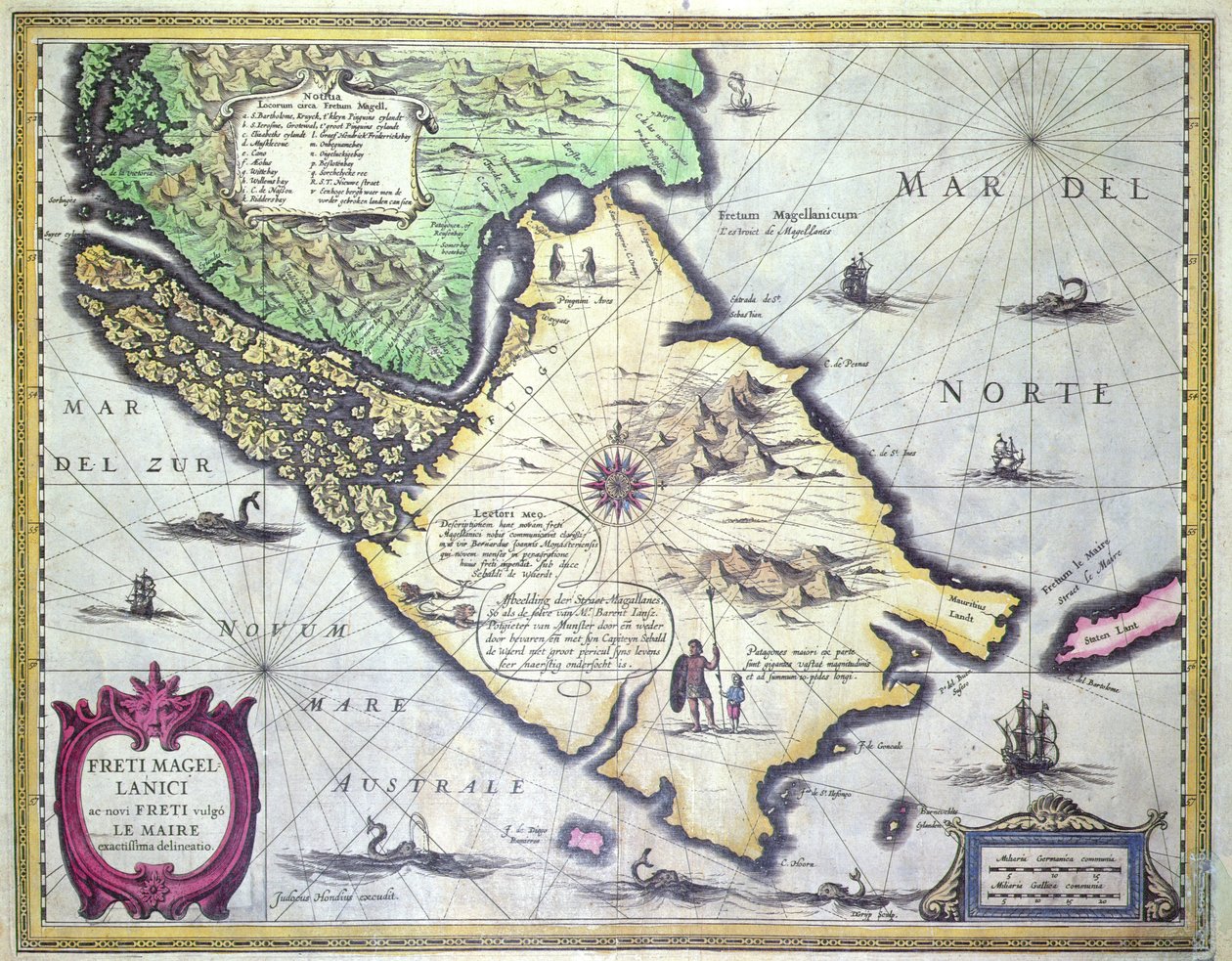
Map of the Magellan Straits, Patagonia by Dutch School

Map of the Magellan Straits, Patagonia

(Map of the Magellan Straits, Patagonia (colour engraving))


Dutch School

€ 139.82
Includes 13.5% VAT
   Configure art print
Undated  ·  colour engraving  ·  Image ID: 103966

Cultural Circles  ·  Cartography

Map of the Magellan Straits, Patagonia by Dutch School. Available as an art print on canvas, photo paper, watercolor board, natural paper, or Japanese paper.
chile · tierra del fuego · south america · compass · cape horn · pacific ocean · atlantic · argentina · mapping · cartography · jodocus · freti magellanici · exploration · cartouche · Private Collection / Bridgeman Images
Other color versions of this image  
AR/3D   View in 3D / AR zu Favoriten hinzufügen   Add to favorites    Change wall color    View picture in a room
0 Reviews

Configure art print

Picture Frame

Medium & Stretcher

Glass & Passepartout

Miscellaneous & Extras

 Save / compare configuration
Preview Icon

Summary

Gemälde
Veredelung
Keilrahmen
Museumslizenz

€ 139.82
(inkl. 20% MwSt)
   Add to cart

Bildschärfe: PERFEKT

If you'd like us to adjust the brightness, colors, or crop the image, we're happy to do this for you at no extra cost. Just get in touch!

Similar artworks selected for you

River Orinoco, Rio Amazonas, Venezuela, Northeast Brazil, in Tabula Magellanica: Map of Strait of Magellan Dutch Trade Map of the Baltic Sea Extreme northeast coastline of the States, in Freti Magellanici ac Novi Freti Vulgo Le Maire Exactissima Delineatio Mexico, in Oversize Atlas Titled Marca D Map of Nova Belgica or New Belgium and of Anglia Nova or New England Lake of Geneva, in Map of Livonia Theatrum Orbis Terrarum Map of Livonia Die custe va Lijfflandt met de eijlanden daer beneffens Peru, in Map of Netherlands, from Theatrum Orbis Terrarum by Abraham Ortelius Argentina, Chile, Strait of Magellan, Land of Fire, in Chart of the English Channel Map of the North Coast of England Near Newcastle upon Tyne Map of the newly discovered Nova Zembla, illustration from Diarium Nauticum, seu vera descriptio trium navigationum admirandarum... by Gerrit de Veer The first western atlas map of China, from the Ortelius Theatrum atlas, 1584 Cape Sagres (or Sacred Cape) at the end of Portugal after the portulan of Luca J. Waghenaer Treesor of zeevaert printed in Leiden in 1592 Southeast, in Straits of Gibraltar to Alicante as far inland as the Guadalquivir valley and Seville and the coast of North Africa, in East Friesland 1584 Map Strait of Magellan, from Theatrum Orbis Terrarum by Willem and Joan Blaeu Istria, in Egypt, Israel, Lebanon Map of the north coast of England near Newcastle upon Tyne. Map of the north coast of England, beginning from Robin Hood
Show more similar artworks

More art prints by Dutch School

Map of New Holland, now Australia, and of New Zealand, drawn from information collected during trips undertaken by Abel Janszoon Tasman (1603-1659) and Willem Janszoon (1570-1630) Stellatum Planisphaerium, a planisphere with signs of the Zodiac Plaque with a Chinoiserie Landscape and Gilt Details, c. 1680 Terrarum Orbis Tabula, after G. a Schagen. Published c. 1689 Martin Luther Preaching, detail from the altarpiece of the Church of Torslunde A Dodo Sint Eustatius in the Dutch Antilles, with West Indiamen Massed in the Road off Oranjestad Rock the Brazilian Miracle of Our Lady of Nazaré. Our Lady of Nazaré Church (Largo Nossa Senhora da Nazaré). Portugal. Map of the Magellan Straits, Patagonia Map of Greece, Hungary and their surrounding countries Map of the Cape of Good Hope. Table Bay, South Africa. King Alvaro I of Kongo receiving the Dutch ambassadors, an illustration from the The Coronation of William of Orange (1650-1702) and Mary (1662-94), at Westminster Abbey, 21st April 1689 Compass Rose, from a Blue Atlas, published in Amsterdam, 1697
Show more works by Dutch School

More motifs from the category Cartography

Map of the Americas, 1631 Ayer MS 1801 Map 1: Map of lands in the Tultepec and Jaltocan regions adjacent to the Hacienda de Santa Ines, Mexico, published 1569 An Astronomer, detail from a map of the planets, from ‘A Celestial Atlas, or The Harmony of the Universe’ (Atlas coelestis seu harmonia macrocosmica), published by Joannes Janssonius, Amsterdam, 1660-61 BT1.47.9 The Dedication to Queen Elizabeth I from a Book of Maps of England and Wales by Christopher Saxton, published 1579 Map of Canterbury, from Map of New Belgium and New England, published in Amsterdam c.1640 Ireland, detail from a Renaissance map of Europe, after Jacopo Russo, 1528 Map of South Africa Illustrating Dr. Livingstone Map of Southern Britain, coloured to show geological areas of interest, annotated by William Smith (1769-1839) This map of the City of New York and Island of Manhattan as laid out by the Commissioners appointed by the Legislature ..., 1853 A Map of St Paul Map of Europe and Africa, from the ‘Sala del Mappamondo’ (Hall of the World Maps) Fol. 99 Map of Saint-Savinien on the Charente River in 1713, from Map of Modern London and its Environs, 1845 Map of the Austro-Hungarian Empire, illustration from a French geography school textbook, 1905
View More from "Cartography"

A selection of our top sellers

Pandemonium, 1841 The Symphony of the Cat, drawing by Moritz von Schwind of 1868. Staatliche Kunsthalle Karlsruhe. Landscape with Church and Path Lady Godiva Nude in an Interior The Golden Fish The Girls Farm Garden with Sunflowers, 1905-1906 The Water Lily Pond in the Evening The Roundel in the Hedge Garden with a Flower Waterer The Man with the Golden Helmet, c. 1650 Café Terrace, Place du Forum, Arles, 1888 Pine Forest, left screen Snow at Benzaiten Shrine in the Pond of Inokashira, 1843-1847 Summer, 1573
Show more artworks


What our customers think about us


Frequently Asked Questions about Meisterdrucke


Personalizing your art print at Meisterdrucke is simple and intuitive: Choose a frame, set the image size, pick a printing medium, and add suitable glazing or a stretcher frame. We also offer additional customization options like mats, fillets, and spacers. If you have any questions, our customer service team is ready to help you create your perfect artwork.

At Meisterdrucke, you can visualize your configured artwork directly in your own room. Simply upload a photo of your space and see how the artwork looks in it. If you're visiting us on a mobile device — phone or tablet — our augmented reality feature brings the picture to life and projects it right into your room. A unique experience that combines art and technology.

Choosing the right medium is often a matter of personal taste. To give you a better idea, we've provided some images for each medium. We also offer a sample set of all paper variants, so you can decide not just visually but by touch as well. You can order the sample set free of charge — only shipping costs apply.

Don't worry! At Meisterdrucke, we don't just process orders mechanically. Every order is manually reviewed by our team. If we spot any inconsistencies or issues with your configuration, we'll get in touch with you right away. And of course, our friendly and patient support team is always here to help you with your configuration. We'll work with you by phone or email to adjust your image so the final result is exactly what you had in mind.


Still have questions?

Are you interested in an art print from our manufactory but still unsure? Do you need advice on choosing the medium or help with the order?

Our experts are happy to assist you.

+43 4257 29415
support@meisterdrucke.com
Mo-Do: 7:00 - 16:00 | Fr: 7:00 - 13:00

Still have questions?

Are you interested in an art print from our manufactory but still unsure? Do you need advice on choosing the medium or help with the order?

Our experts are happy to assist you.

+43 4257 29415
support@meisterdrucke.com
Mo-Do: 7:00 - 16:00 | Fr: 7:00 - 13:00


Meisterdrucke

   Kärntner Strasse 46
        9586 Finkenstein am Faaker See
        Austria
        +43 4257 29415
        support@meisterdrucke.com
Other languages

                   
Erfahrungen & Bewertungen zu Meisterdrucke
Post.at DHL Express Quehenberger Cargoboard
Kaiser Franz Joseph

Meisterdrucke
Kärntner Strasse 46
9586 Finkenstein am Faaker See · Austria
+43 4257 29415 · support@meisterdrucke.com
Post.at DHL Express Quehenberger Cargoboard


(c) 2026 meisterdrucke.ie