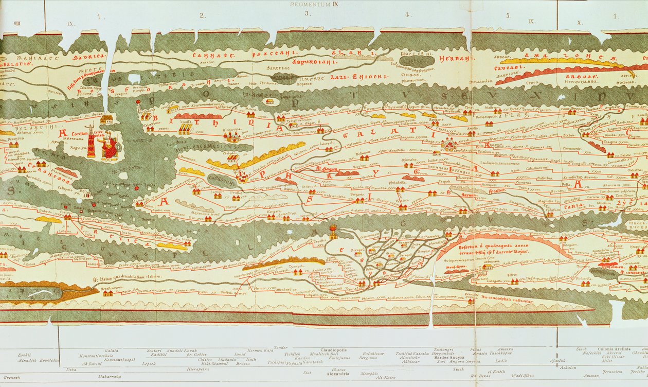
Detail of Constantinople and the Middle East from the Peutinger Map Copy by Unbekannt Unbekannt

Detail of Constantinople and the Middle East from the Peutinger Map Copy

(Detail of Constantinople and the Middle East from the Peutinger map copy)


Unbekannt Unbekannt

€ 127.43
Enthält 13.5% MwSt.
   Configure art print
Undated  ·  Picture ID: 100873

Nonclassified artists  ·  Cartography

Detail of Constantinople and the Middle East from the Peutinger Map Copy by Unbekannt Unbekannt. Available as an art print on canvas, photo paper, watercolor board, uncoated paper or Japanese paper.
gallo roman · turkey · river · cartography · geography · rivers · settlements · roads · tabula peutingeriana · carte · galatia · constantinople · middle east · eastern mediterranean · turkish · imperial · crete · red sea · nile · alexandria · asia minor · geographical · river · road · military · roman empire · city · capital · cities · towns · transport · itinerarium · medieval copy · c13th · roman · network · road map · route · roman road · itinerary · planisphere · tabula peutingerina · peutinger · table · tabula · miles · distances · distance · cursus publicus · africa · north africa · mediterranean · coast · settlement · tribes · rivers · facsimile · medieval · symbols · phrygia · decorated · antiquity · istanbul · jordan · nile delta · delta · Jerusalem · Aegyptus · Bibliotheque Nationale, Paris, France / Bridgeman Images
AR/3D   View in 3D / AR zu Favoriten hinzufügen   Add to favorites    Select wall color    View painting in a room
0 Reviews

Configure art print

Picture Frame

Medium & Stretcher

Glass & Passepartout

Miscellaneous & Extras

 Save / compare configuration
Preview Icon

Summary

Gemälde
Veredelung
Keilrahmen
Museumslizenz

€ 127.43
(inkl. 20% MwSt)
   Add to cart

Bildschärfe: PERFEKT

Should you desire adjustments to brightness and color, or a custom crop of the motif, we are happy to make these changes at no additional cost to you. Please do not hesitate to contact us.

Similar artworks selected for you

Peutinger Table Representing the Roman Ways in Egypt and Turkey. Road Map of the 13th Century Based on a Map of the Roman Empire of the 3rd Century Part of the Tabula Peutingeriana, an illustrated itinerarium of the road network in the Roman Empire. Detail of Italy from the Peutinger map copy Detail of Italy from the Peutinger map (detail) Plan of the Battle of Sekigahara, October 21st 1600 Map of Antietam, Sharpsburg and Vicinity, Maryland Heilbronn and its Eastern Surroundings 1578 Map of Jodoigne Photograph of a French Map Showing the Battlefields of Verdun, September 1916 Bavarian Land Tables of 1568 (Table 10) Geological Map of London and the Surrounding Area Detail of Italy from the Peutinger map copy Shanzhou Quan Tu (translation) Kliver Flözkarte in the Area of the Ruhbachtal Chart of Leix and Offaly, Ireland, c.1590 State: Hesse, Thuringia, Bavaria, Baden-Württemberg, Germany Map from the National Library Map of Seneffe, Belgium Detail of Constantinople from the Peutinger Map (detail) Map of the Austerlitz battle, 2nd December 1805 A Survey of English Harbour in the Island of Antigua made by Order of Commissioner Laforey in 1783 Bavarian Maps of 1568 (Plate 20) Plan and View of the Battle of Waterloo with the Position of the English in Red, the Belgians in Yellow, the Prussians in Green and the French in Blue Map (from Beauvais to Senlis) of Cassini Prepared by the Cassini Family, Especially by Cesar-François Cassini (Cassini III) and His Son Jean-Dominique Cassini (Cassini IV). The Leves were Made between 1756 and 1789 and the 181 Sheets of the Map were Publis The Battle of Viborg Bay, 1790 Map, 1790 Map from the National Library Map of the Battle of Gettysburg, Pennsylvania, 1-3 July 1863 Plan of the Attack on Sholapore, illustration from Cassell Plan of the Battle of Kunersdorf, August 12th, 1759 Tongguk Chido
Show more similar artworks

Other art prints by Unbekannt Unbekannt

Lascaux Cave Painting, Bordeaux, France Wall painting of a bird in a garden, Pompeii, 1st century AD Oscar Wilde and Lord Alfred Douglas Guhyasamaja, Akshobhyavajra Night Parade of a Hundred Demons Bison Painting in Altamira caves, Upper Paleolithic museum, Santander, Cantabria, Spain Death comes for the Unbelieving Woman, from The Unicorn in Captivity Sidewall Archer, cave painting, Tassili n Examples of Ionic and Corinthian orders in Greek architecture, from The National Encyclopaedia, published c.1890 View of Milan Cathedral The unbroken seal on Tutankhamun Early light bulbs: first commercial light bulb and electric filament lamp made by Thomas Alva Edison Map of the world, based on descriptions and co-ordinates given in
Discover more works by Unbekannt Unbekannt

Other motives from the category Cartography

Map of the Battle of Novi, published by William Blackwood and Sons, Edinburgh and London, 1848 Map of the parish of St Paul Map of Sixteenth Century Egypt, from the Map of Padua, from Map of Laputa (flying island top right) and Balnibarbii (main port Maldonada) from Part III: A Voyage to Laputa, Balnibarbi, Luggnagg, Glubbdubdrib, and Japan in Gulliver Map of the parish of St Giles in the Fields, London Map of the world with possessions of the British Empire coloured red, c.1870 Map of the City of New York [as far north as East 53rd Street], 1885 Map of Berlin, 1737 Map of Berlin, printed by C.L. Keller, Berlin, 1890 Map of Spain Map of Brazil Map of Rome Map of Europe Northern Africa and Western Asia, Orbis Veteribus Notus, from Septentrionalium terrarum descriptio, map of the Arctic, 1595
View More from "Cartography"

Excerpt from our top sellers

Escaping Criticism The School of Athens The Great Day of His Wrath Water Lilies, the Cloud The Tortoise Trainer The Garden of Earthly Delights The Langlois Bridge at Arles with Washerwomen Portrait of Joan of Arc with flag and lilies on the background of Notre Dame Cathedral Morning in a Pine Forest Flute Concert with Frederick the Great in Sanssouci, 1850-1852 Winter Landscape, 1835-8 Vesuvius in Eruption Dante and Virgil March of the Workers, Mexico City, 1926 Wheatfield Under Thunderclouds
Show More Artworks


What our customers think about us


Frequently Asked Questions about Meisterdrucke


Personalizing your art print at Meisterdrucke is a simple and intuitive process that allows you to design an artwork exactly to your specifications: Choose a frame, determine the image size, decide on a printing medium, and add suitable glazing or a stretcher frame. We also offer customization options such as mats, fillets, and spacers. Our customer service is available to help you design your perfect artwork.

At Meisterdrucke, you have the fascinating option to visualize the artwork you configured directly in your own space. For a tailored preview, simply upload a photo of your room and let the artwork appear on it. If you visit us via a mobile device, be it a phone or tablet, our augmented reality feature brings the image to life and seamlessly projects it into your space. An experience that uniquely combines art and technology.

Choosing the medium is often a matter of personal taste. To give you a clearer idea, we have provided some images for each medium. For a holistic experience, we also offer you a sample set of all paper variants so you can make a decision not just visually but also haptically. You can take advantage of the sample set free of charge – only the shipping costs will apply. You can order the sample set directly.

Do not worry. At Meisterdrucke, we do not proceed mechanically. We manually review each order. If there are any inconsistencies or peculiarities in the configuration, we will immediately contact you. Of course, our courteous and patient support is always at your side to assist you with the configuration. Together with you, we adjust your image by phone or email so that the final result exactly meets your expectations.


Do you have any questions?

Are you interested in an art print from our manufactory but still unsure? Do you need advice on choosing the medium or help with the order?

Our experts are happy to assist you.

+43 4257 29415
support@meisterdrucke.com
Mo-Do: 7:00 - 16:00 | Fr: 7:00 - 13:00

Do you have any questions?

Are you interested in an art print from our manufactory but still unsure? Do you need advice on choosing the medium or help with the order?

Our experts are happy to assist you.

+43 4257 29415
support@meisterdrucke.com
Mo-Do: 7:00 - 16:00 | Fr: 7:00 - 13:00


Meisterdrucke

   Kärntner Strasse 46
        9586 Finkenstein am Faaker See
        Austria
        +43 4257 29415
        support@meisterdrucke.com
Other languages

                   
Erfahrungen & Bewertungen zu Meisterdrucke
Partner Logos

Kaiser Franz Joseph

Meisterdrucke
Kärntner Strasse 46
9586 Finkenstein am Faaker See · Austria
+43 4257 29415 · office@meisterdrucke.com
Partner Logos


(c) 2025 meisterdrucke.ie