Search by artist, work title or style – e.g. Monet, Starry Night, Impressionism, Hokusai wave, nude. Describe the scene – e.g. green meadow, abstract with lots of red, dark oil painting, standing nude next to a tree.

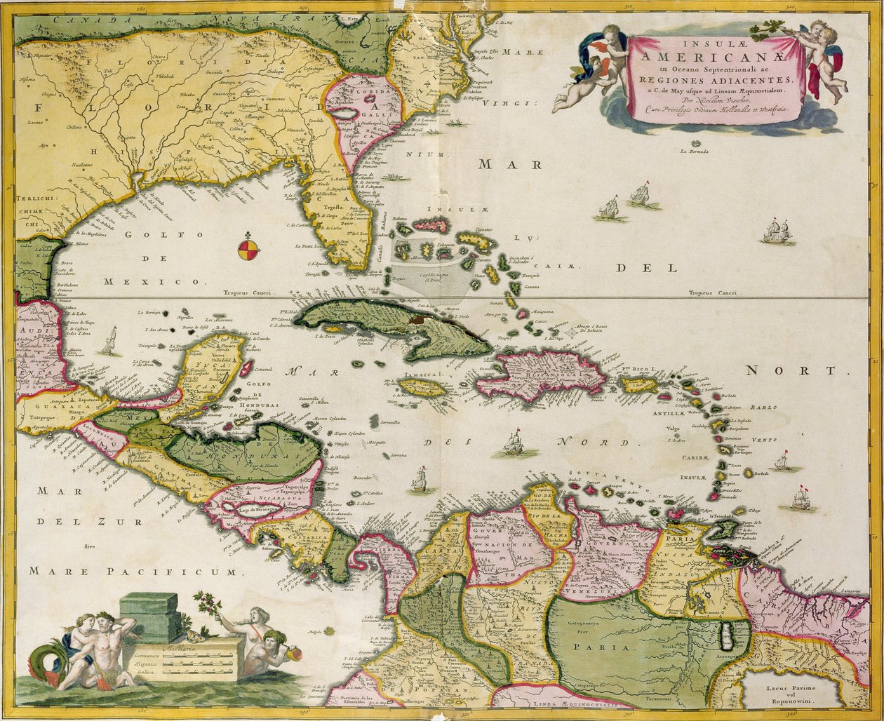
Map of Central America by Netherlandish School

Map of Central America

(Map of Central America )


Netherlandish School

€ 123.84
Enthält 13.5% MwSt.
   Configure art print
Undated  ·  coloured engraving  ·  Picture ID: 432970

Cultural Circles  ·  Cartography

Map of Central America by Netherlandish School. Available as an art print on canvas, photo paper, watercolor board, uncoated paper or Japanese paper.
gulf of mexico · caribbean · atlantic ocean · colonial · island · islands · cuba · mexico · martinique · guadeloupe · jamaica · el salvador · antilles · dominican republic · west indies · cartouche · compass · coast · coastal · empire · cartography · Vorontsov Palace, Crimea, Ukraine / Bridgeman Images
AR/3D   View in 3D / AR zu Favoriten hinzufügen   Add to favorites    Select wall color    View painting in a room
0 Reviews

Configure art print

Picture Frame

Medium & Stretcher

Glass & Passepartout

Miscellaneous & Extras

 Save / compare configuration
Preview Icon

Summary

Gemälde
Veredelung
Keilrahmen
Museumslizenz

€ 123.84
(inkl. 20% MwSt)
   Add to cart

Bildschärfe: PERFEKT

Should you desire adjustments to brightness and color, or a custom crop of the motif, we are happy to make these changes at no additional cost to you. Please do not hesitate to contact us.

Similar artworks selected for you

Caribbean, Honduras and Florida, in Archipelago of Mexico Including the Islands of Cuba, Hispaniola, Jamaica, etc. A New Map of the English Plantations in America Map of the Mexican Archipelago The Caribbean Sea: The Bermuda Triangle between the Bermuda Archipelago, Miami, and Puerto Rico. According to Wilhelm Blaeu Gulf of Mexico and the Caribbean, from Blaeu New and accurate map of the West Indies The Caribbean Sea: Gulf of Mexico and Caribbean Sea from the Atlas of Wilhelm Blaeu North America Map of Central and North America, Published in 1700, Paris Gulf of Mexico chart by de la Cruz Mexico and Florida East Canada, East United States, Mexico, Guatemala, El Salvador, Belize, Honduras, Nicaragua, Costa Rica, Panama, Antigua and Barbuda, The Bahamas, Barbados, Cuba, Dominica, Jamaica, Grenada, Haiti, Dominican Republic, Saint Kitts and Nevis, Saint Lucia Map of America - Corrected and Enlarged Map of North America Daniel Keller. Asiae nova descriptio (Antwerp, 1590) Trading Map of the West Indies, 1707 (hand coloured print) Map of the Americas, 1631 Accurate Delineation of the Islands of Hispaniola and Cuba with Surrounding Islands Plate depicting the map of Southern America General map extending from India and Ceylon to northwestern Australia by way of southern Japan, the Philippines, the Malay Peninsula and the Indonesian archipelago Map of America, from the Mercator Atlas, published by Jodocus Hondius, Amsterdam, 1606 Map of East India (South and Southeast Asia: Pakistan, India, Nepal, Bangladesh, Burma, Sri Lanka, Thailand, Malaysia, Vietnam, Cambodia, Laos, Philippines, Singapore and Indonesia) Map of the West Indies, 18th century Map of the Americas South and North America Map of Asia from the Blaeu Atlas American Islands in the North Ocean with Adjacent Lands The Indian Subcontinent to the Philippines by Way of the Northern Portions of the Indonesian Archipelago and the Malay Peninsula
Show more similar artworks

Other art prints by Netherlandish School

The Unicorn in Captivity Allegorical figure of the Roman Empire, Romulus and Remus Five Nude Soldiers Holding Poles, Two Wearing a Helmet, and Three Nude Women Frontispiece for Emile by Jean-Jacques Rousseau, 1762 Margaret of York (1446-1503) Duchess of Burgundy, c.1477 The Nautilus cup, c.1560 The John the Fearless, Duke of Burgundy (1371-1419) Deaths from Famine, from The Annunciation, from a folding altarpiece Portrait of Roman Emperor Romulus Augustulus A Man Reading, c.1660 Madonna with the Christ Child Writing, 1410-20 Mutilation of Marie Therese Louise de Savoie-Carignan, Princess of Lamballe on 3rd September 1792
Discover more works by Netherlandish School

Other motives from the category Cartography

A Map of Mile End, London, 1746 A New Map of the Kingdom of England and the Principality of Wales, 1669 Map of Westminster from Map of Berlin, Published by D. Reimer Verlag, Berlin Map of Transylvania, from an atlas, Amsterdam, 1657 Map of Galicia with the route of the French army and a log, from the campaign in January, 1809 Map of the Strait of Magellan Map of Animals in Africa Map of the world with possessions of the British Empire coloured red, c.1870 Detail from a Catalan World Map Map of the Battle of Vitoria, published by William Blackwood and Sons, Edinburgh and London, 1848 Map of Nuremberg, Ulm, and Saltzburg, from Map of Trento, from Map of Caernarvon Map of Silesia, from an Atlas
View More from "Cartography"

Excerpt from our top sellers

Murnau, Burggrabenstrasse The Harvesters Napoleon Crossing the Alps Caresses, 1896 After Sunset Waterlilies, Evening Tulip Fields with the Rijnsburg Windmill Peasant Wedding Sunset on the Seine at Lavacourt, Winter Effect The Sin Setting Sun Birth of Venus Coffee Garden at Ammersee Two Men Contemplating the Moon Moonrise
Show More Artworks


What our customers think about us


Frequently Asked Questions about Meisterdrucke


Personalizing your art print at Meisterdrucke is a simple and intuitive process that allows you to design an artwork exactly to your specifications: Choose a frame, determine the image size, decide on a printing medium, and add suitable glazing or a stretcher frame. We also offer customization options such as mats, fillets, and spacers. Our customer service is available to help you design your perfect artwork.

At Meisterdrucke, you have the fascinating option to visualize the artwork you configured directly in your own space. For a tailored preview, simply upload a photo of your room and let the artwork appear on it. If you visit us via a mobile device, be it a phone or tablet, our augmented reality feature brings the image to life and seamlessly projects it into your space. An experience that uniquely combines art and technology.

Choosing the medium is often a matter of personal taste. To give you a clearer idea, we have provided some images for each medium. For a holistic experience, we also offer you a sample set of all paper variants so you can make a decision not just visually but also haptically. You can take advantage of the sample set free of charge – only the shipping costs will apply. You can order the sample set directly.

Do not worry. At Meisterdrucke, we do not proceed mechanically. We manually review each order. If there are any inconsistencies or peculiarities in the configuration, we will immediately contact you. Of course, our courteous and patient support is always at your side to assist you with the configuration. Together with you, we adjust your image by phone or email so that the final result exactly meets your expectations.


Do you have any questions?

Are you interested in an art print from our manufactory but still unsure? Do you need advice on choosing the medium or help with the order?

Our experts are happy to assist you.

+43 4257 29415
support@meisterdrucke.com
Mo-Do: 7:00 - 16:00 | Fr: 7:00 - 13:00

Do you have any questions?

Are you interested in an art print from our manufactory but still unsure? Do you need advice on choosing the medium or help with the order?

Our experts are happy to assist you.

+43 4257 29415
support@meisterdrucke.com
Mo-Do: 7:00 - 16:00 | Fr: 7:00 - 13:00


Meisterdrucke

   Kärntner Strasse 46
        9586 Finkenstein am Faaker See
        Austria
        +43 4257 29415
        support@meisterdrucke.com
Other languages

                   
Erfahrungen & Bewertungen zu Meisterdrucke
Post.at DHL Express Quehenberger Cargoboard
Kaiser Franz Joseph

Meisterdrucke
Kärntner Strasse 46
9586 Finkenstein am Faaker See · Austria
+43 4257 29415 · office@meisterdrucke.com
Post.at DHL Express Quehenberger Cargoboard


Meisterdrucke 2746 Bewertungen auf ProvenExpert.com

(c) 2025 meisterdrucke.ie