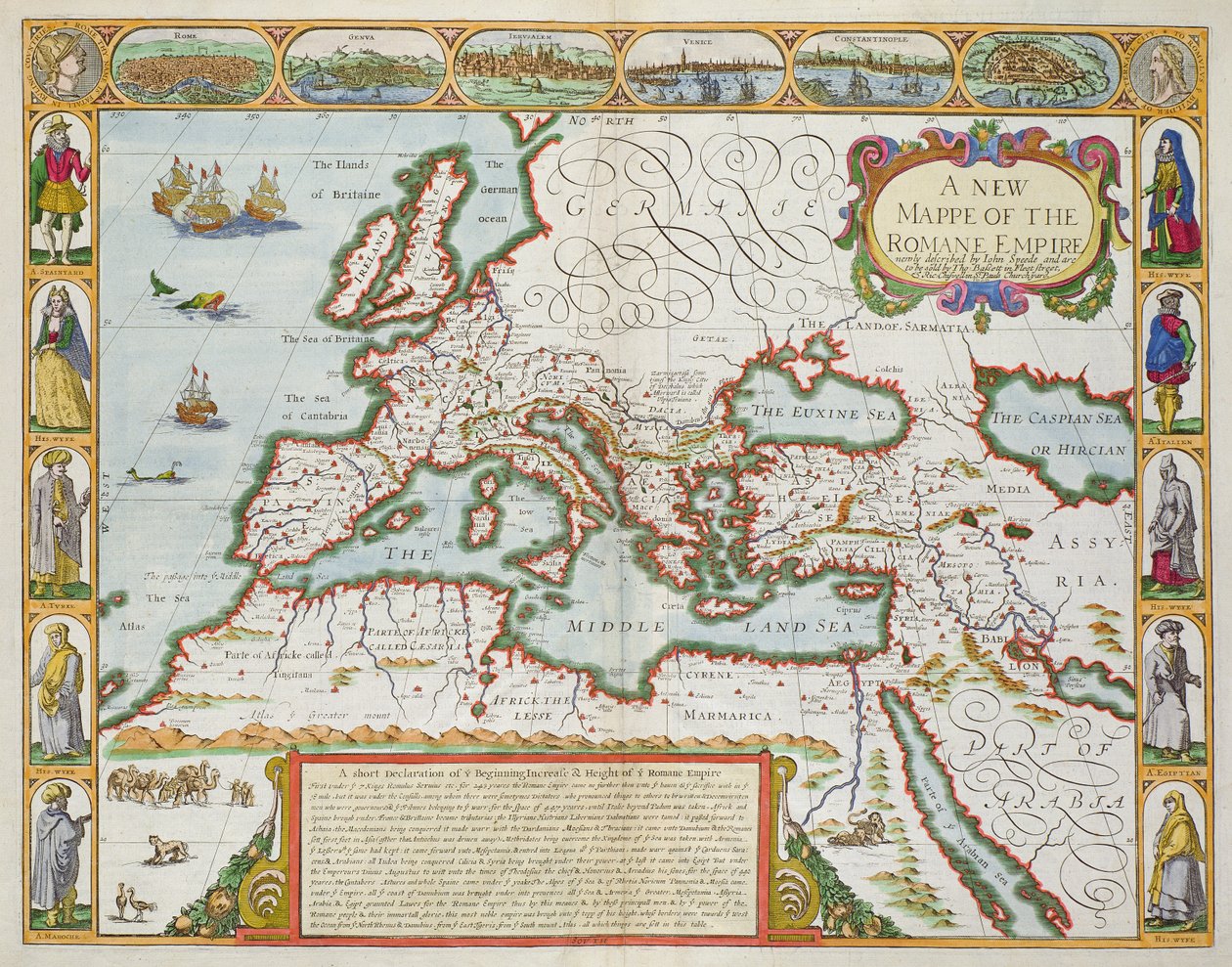
A New Map of the Roman Empire, from

A New Map of the Roman Empire, from 'A Prospect of the Most Famous Parts of the World', pub. by Bassett and Chiswell, 1676

(A New Map of the Roman Empire, from 'A Prospect of the Most Famous Parts of the World', pub. by Bassett und Chiswell, 1676 (hand coloured plate engraving))


John Speed

€ 129.74
Enthält 13.5% MwSt.
   Configure art print
1676  ·  hand coloured plate engraving  ·  Picture ID: 36077

Nonclassified artists  ·  Cartography

A New Map of the Roman Empire, from 'A Prospect of the Most Famous Parts of the World', pub. by Bassett and Chiswell, 1676 by John Speed. Available as an art print on canvas, photo paper, watercolor board, uncoated paper or Japanese paper.
plan · mapping · cartography · europe · mappe · romane empire · c17th · traditional costume · traditional dress · rome · genoa · jerusalem · venice · constantinople · alexandria · john speede · thomas bassett · richard chiswell · O'Shea Gallery, London, UK / Bridgeman Images
AR/3D   View in 3D / AR zu Favoriten hinzufügen   Add to favorites    Select wall color    View painting in a room
0 Reviews

Configure art print

Picture Frame

Medium & Stretcher

Glass & Passepartout

Miscellaneous & Extras

 Save / compare configuration
Preview Icon

Summary

Gemälde
Veredelung
Keilrahmen
Museumslizenz

€ 129.74
(inkl. 20% MwSt)
   Add to cart

Bildschärfe: PERFEKT

Should you desire adjustments to brightness and color, or a custom crop of the motif, we are happy to make these changes at no additional cost to you. Please do not hesitate to contact us.

Similar artworks selected for you

From Theatrum Orbis Terrarum Map of Europe Map of Europe. Atlas by William Blaeu (1571 - 1638). Amsterdam 1635 Map of Europe Europe Map From: Atlas Maior Map of Europe Map of Europe from the Blaeu Atlas Atlas sive Cosmographicae Meditationes de Fabrica Mundi et Fabricati Fugura Europe: Livonia, Russia Map of Europe by Abraham Ortelius Europae Map of Turkey, from Theatrum Orbis Terrarum 1700 Map of the Eastern Mediterranean Map of Europe, from Theatrum Orbis Terrarum Map of Europe, La Cosmographie Universelle d Map of the Roman Empire, Theatrum Orbis Terrarum, Abraham Ortelius, Antwerp Map of Europe 1695 Dutch Map of the Eastern Mediterranean Showing the Travels of St. Paul Europae From: Theatrum Orbis Terrarum Europe The Mediterranean region 1584 Map of Greece Description of the European Continent. Geography Map from Theatrum Orbis Terrarum by Abraham Ortelius Croatia, south Bosnia and Herzegovina, south Serbia, south Bulgaria, Montenegro, Albania, Macedonia, Greece, West Turkey Map of Asia. Plate from an Atlas by Willem Janszoon Blaeu Venezuela, Trinidad, Tobago, Tortuga, Antilles, Caribbean, in Map of the Voyage of the Argonauts, from the Map of Asia from the Bleau Atlas Asia, in
Show more similar artworks

Other art prints by John Speed

A New and Accurate Map of the World The Turkish Empire Map of Tartary by John Speed Maps of Holy Island and Farne Island, Northumberland The Turkish Empire, from The Countie of Nottingham (engraved by Jodocus Hondius from John Speed Irish The West Ridinge of Yorkeshyre, engraved by Jodocus Hondius from John Speed Buckinghamshire, engraved by Jodocus Hondius (1563-1612) from John Speed Devonshire, engraved by Jodocus Hondius from John Speed Cambridgeshire, engraved by Jodocus Hondius from John Speed Cumberland and the Ancient City of Carlile Map Depicting The Invasions of England and Ireland With All Their Civil Wars Since the Conquest, c.1627 Huntington, engraved by Jodocus Hondius from John Speed Rutlandshire with Oukham and Stanford, engraved by Jodocus Hondius from John Speed
Discover more works by John Speed

Other motives from the category Cartography

Map of Hamburg and the surrounding area, published in Nuremberg Map of Alexander the Great Map of the Battle of Trafalgar, published by William Blackwood and Sons, Edinburgh and London Map of Canada, Published Paris, 1703 Map of the travels of Abraham, Isaac and Jacob, 1652 Map of Paris, 1620 (detail) A Map inspired by Candide by Francois Voltaire for a competition organised by the Ecole Nationale des Ponts et Chaussees in Paris Map of the Holy Land, pub. by Jan Barend Elwe, Amsterdam, 1742 Copy of Map showing the Toll-Gates and Principal Bars within Six Miles of Charing-Cross, exhibited to Lord Palmerston by the Toll Reform Committee The Middle East, from an Atlas of the World in 33 Maps, Venice, 1st September 1553 Glyph map of Aztec migration from Aztlan to Tenochtitlan, published c.1830 Wyld Map of Laos and the Mekong River Showing the Route of the Voyage of Henri Mouhot, Illustration from Travels in the Central Parts of Indo-China (Siam), Cambodia, and Laos During the Years 1858, 1859 Mappa Mundi, c.1290 Plan and Map of Saint-Jean-Pied-de-Port, from the Atlas Louis XIV, 1683-88
View More from "Cartography"

Excerpt from our top sellers

Flute Concert with Frederick the Great in Sanssouci, 1850-1852 Princess Tuvstarr is Still Sitting There Wistfully Looking into the Water, 1913 Beach Study Alley in Arles with Houses Dance from the series The Arts Mowing Mountain Farmers Summer Night by the Beach Cupid as Victor Standing Woman in Red The Zaporozhye Cossacks Writing a Letter to the Turkish Sultan The Luncheon: Monet The Olive Trees Reduced Weight Melencolia I Yacht Approaching the Coast
Show More Artworks


What our customers think about us


Frequently Asked Questions about Meisterdrucke


Personalizing your art print at Meisterdrucke is a simple and intuitive process that allows you to design an artwork exactly to your specifications: Choose a frame, determine the image size, decide on a printing medium, and add suitable glazing or a stretcher frame. We also offer customization options such as mats, fillets, and spacers. Our customer service is available to help you design your perfect artwork.

At Meisterdrucke, you have the fascinating option to visualize the artwork you configured directly in your own space. For a tailored preview, simply upload a photo of your room and let the artwork appear on it. If you visit us via a mobile device, be it a phone or tablet, our augmented reality feature brings the image to life and seamlessly projects it into your space. An experience that uniquely combines art and technology.

Choosing the medium is often a matter of personal taste. To give you a clearer idea, we have provided some images for each medium. For a holistic experience, we also offer you a sample set of all paper variants so you can make a decision not just visually but also haptically. You can take advantage of the sample set free of charge – only the shipping costs will apply. You can order the sample set directly.

Do not worry. At Meisterdrucke, we do not proceed mechanically. We manually review each order. If there are any inconsistencies or peculiarities in the configuration, we will immediately contact you. Of course, our courteous and patient support is always at your side to assist you with the configuration. Together with you, we adjust your image by phone or email so that the final result exactly meets your expectations.


Do you have any questions?

Are you interested in an art print from our manufactory but still unsure? Do you need advice on choosing the medium or help with the order?

Our experts are happy to assist you.

+43 4257 29415
support@meisterdrucke.com
Mo-Do: 7:00 - 16:00 | Fr: 7:00 - 13:00

Do you have any questions?

Are you interested in an art print from our manufactory but still unsure? Do you need advice on choosing the medium or help with the order?

Our experts are happy to assist you.

+43 4257 29415
support@meisterdrucke.com
Mo-Do: 7:00 - 16:00 | Fr: 7:00 - 13:00


Meisterdrucke

   Kärntner Strasse 46
        9586 Finkenstein am Faaker See
        Austria
        +43 4257 29415
        support@meisterdrucke.com
Other languages

                   
Erfahrungen & Bewertungen zu Meisterdrucke
Post.at DHL Express Quehenberger Cargoboard
Kaiser Franz Joseph

Meisterdrucke
Kärntner Strasse 46
9586 Finkenstein am Faaker See · Austria
+43 4257 29415 · office@meisterdrucke.com
Post.at DHL Express Quehenberger Cargoboard


Meisterdrucke 2717 Bewertungen auf ProvenExpert.com

(c) 2025 meisterdrucke.ie