Search by artist, work title or style – e.g. Monet, Starry Night, Impressionism, Hokusai wave, nude. Describe the scene – e.g. green meadow, abstract with lots of red, dark oil painting, standing nude next to a tree.

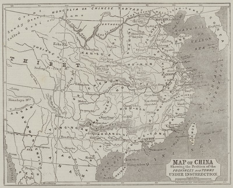
Map of China showing the Position of the Provinces and Towns under Insurrection by John Dower

Map of China showing the Position of the Provinces and Towns under Insurrection

(Map of China showing the Position of the Provinces and Towns under Insurrection )


John Dower

€ 130.4
Enthält 13.5% MwSt.
   Configure art print
Undated  ·  Gravur  ·  Picture ID: 163217

Nonclassified artists  ·  Cartography

Map of China showing the Position of the Provinces and Towns under Insurrection by John Dower. Available as an art print on canvas, photo paper, watercolor board, uncoated paper or Japanese paper.
Private Collection / Bridgeman Images / Look and Learn
AR/3D   View in 3D / AR zu Favoriten hinzufügen   Add to favorites    Select wall color    View painting in a room
0 Reviews

Configure art print

Picture Frame

Medium & Stretcher

Glass & Passepartout

Miscellaneous & Extras

 Save / compare configuration
Preview Icon

Summary

Gemälde
Veredelung
Keilrahmen
Museumslizenz

€ 130.4
(inkl. 20% MwSt)
   Add to cart

Bildschärfe: PERFEKT

Should you desire adjustments to brightness and color, or a custom crop of the motif, we are happy to make these changes at no additional cost to you. Please do not hesitate to contact us.

Similar artworks selected for you

Map of the Proposed Route to China from British Burmah A Map of Western Tartary Drawn from the Survey of the Jesuits and Mr. Kyrillow Map of Slavery in the United States Map of China Map of North-East China, Showing the Gulf of Pechili, the Tien-Tsin (Peiho) River, and the Approaches to Pekin Map of China Map Illustrating the Campaign Preceding the Treaty of Campo-Formio, 1797, 1896 Geographic map of the United States of America in March 1861. Slavery states are represented in the run. Written in white, the names of the seven confederate states that separated from the Union: Texas, South Carolina, Mississippi, Florida, Alabama, Georgi Gaul Map of Lower Egypt, Showing the Lines of Railway and Projected Isthmus of Suez Canal China: Sketch-map of China Map of the Gold Region, Published in The Weekly Chart of the Arctic Regions Showing the North West Passage Connecting the Atlantic and Pacific Oceans Northern Italy - Illustrating the Campaigns of 1796 and 1797, 1896 Map of the parts of Europe and Asia adjacent to Constantinople, from New Map for the voyage to the North West coast of Africa, Anno, drawn and printed by Dean & Munday New Universal Geography Western Canada, Including the Five Great Lakes, from Map of the British and German Possessions in Africa Map of Siberia, c1923 Map of Gaul and Part of Britain Persia, Georgia and Independent Tartary, from Dr Livingstone Map of the Russian Campaign, 1812 Egypt and Nubia, Volume III: Map to Illustrate the Sketches of David Roberts, Esq Map of Korea The Empire of China and Island of Japan Map of the Scene of War on the Danube Maps of Africa, Upper Guinea, and the Gold Coast, Showing the Site of the Ashantee War
Show more similar artworks

Other art prints by John Dower

Plan of Constantinople and its Suburbs Map of the Ottoman Empire, Kingdom of Greece, and the Russian Provinces on the Black Sea Map of North-East China, Showing the Gulf of Pechili, the Tien-Tsin (Peiho) River, and the Approaches to Pekin Map of European Russia showing its Earliest Extent, its Encroachments upon Adjacent Countries, and the Present Boundary of the Empire Map Showing the New Frontier Line Between Russia and Turkey as Settled by the Treaty, 30 March 1856 Map of India, Showing the Railways Finished, in Progress and Intended, the Cotton and Coal Districts Map of the Strait of Malacca Map of the Country between the River Alma and Balaklava, illustrating the Advance of the Allied Armies Map of the Country between Auckland and the River Waikato, New Zealand, illustrating the War with the Natives Map of Lower Egypt, Showing the Lines of Railway and Projected Isthmus of Suez Canal Maps of Africa, Upper Guinea, and the Gold Coast, Showing the Site of the Ashantee War Seat of War in the Crimea, Map of the Country between Simpheropol and Baidar to Illustrate the Movements of the Allied and Russian Armies Map of Austria and the German Empire Chart of the Arctic Regions Showing the North West Passage Connecting the Atlantic and Pacific Oceans The Route of Burke and Wills across the Continent of Australia from Cooper
Discover more works by John Dower

Other motives from the category Cartography

Geographic Map of the Azores Map of Scotland, c.1700 Map of South-Eastern Asia and Northern Australia Map of Seville, Cadiz, and Malaga, from Map of Venice, by Sebastian Munster published in Basel, c.1560 Map of the Battle of Friedland, Published by William Blackwood and Sons, Edinburgh and London, 1848 Map and Prospect of London, c.1710 Map of the Austrian Empire Map of the Holy Land, based on descriptions and co-ordinates given in Cosmographica, by Ptolemy (Claudius Ptolemaeus of Alexandria) published in Ulm, Germany, by Johann Reger Map of Zamosc, from Map of Siberia and China from Le Theatre du Monde or Nouvel Atlas, 1645 An inciting map of the Turbid Amazon, illustration from Map of Transylvania, from an atlas, Amsterdam, 1657 Map of Europe after the Peace of Luneville, 1801, from Map of St. Petersburg, c.1750
View More from "Cartography"

Excerpt from our top sellers

Trees and Undergrowth, 1887 Munich Beer Garden The Sailing Boat, Evening Effect Map of the Battle of Trafalgar, published by William Blackwood and Sons, Edinburgh and London The Dutch Proverbs The Great Wave off Kanagawa Waterlilies at Sunset View of a Harbor Some New Year Customs in Galloway Head of a Young Woman with Tousled Hair or, Leda Twelve Sunflowers in a Vase The Bookworm Watercolor No. 326 Composition VIII Lisbeth
Show More Artworks


What our customers think about us


Frequently Asked Questions about Meisterdrucke


Personalizing your art print at Meisterdrucke is a simple and intuitive process that allows you to design an artwork exactly to your specifications: Choose a frame, determine the image size, decide on a printing medium, and add suitable glazing or a stretcher frame. We also offer customization options such as mats, fillets, and spacers. Our customer service is available to help you design your perfect artwork.

At Meisterdrucke, you have the fascinating option to visualize the artwork you configured directly in your own space. For a tailored preview, simply upload a photo of your room and let the artwork appear on it. If you visit us via a mobile device, be it a phone or tablet, our augmented reality feature brings the image to life and seamlessly projects it into your space. An experience that uniquely combines art and technology.

Choosing the medium is often a matter of personal taste. To give you a clearer idea, we have provided some images for each medium. For a holistic experience, we also offer you a sample set of all paper variants so you can make a decision not just visually but also haptically. You can take advantage of the sample set free of charge – only the shipping costs will apply. You can order the sample set directly.

Do not worry. At Meisterdrucke, we do not proceed mechanically. We manually review each order. If there are any inconsistencies or peculiarities in the configuration, we will immediately contact you. Of course, our courteous and patient support is always at your side to assist you with the configuration. Together with you, we adjust your image by phone or email so that the final result exactly meets your expectations.


Do you have any questions?

Are you interested in an art print from our manufactory but still unsure? Do you need advice on choosing the medium or help with the order?

Our experts are happy to assist you.

+43 4257 29415
support@meisterdrucke.com
Mo-Do: 7:00 - 16:00 | Fr: 7:00 - 13:00

Do you have any questions?

Are you interested in an art print from our manufactory but still unsure? Do you need advice on choosing the medium or help with the order?

Our experts are happy to assist you.

+43 4257 29415
support@meisterdrucke.com
Mo-Do: 7:00 - 16:00 | Fr: 7:00 - 13:00


Meisterdrucke

   Kärntner Strasse 46
        9586 Finkenstein am Faaker See
        Austria
        +43 4257 29415
        support@meisterdrucke.com
Other languages

                   
Erfahrungen & Bewertungen zu Meisterdrucke
Post.at DHL Express Quehenberger Cargoboard
Kaiser Franz Joseph

Meisterdrucke
Kärntner Strasse 46
9586 Finkenstein am Faaker See · Austria
+43 4257 29415 · office@meisterdrucke.com
Post.at DHL Express Quehenberger Cargoboard


Meisterdrucke 2755 Bewertungen auf ProvenExpert.com

(c) 2025 meisterdrucke.ie