Search by artist, work title or style – e.g. Monet, Starry Night, Impressionism, Hokusai wave, nude. Describe the scene – e.g. green meadow, abstract with lots of red, dark oil painting, standing nude next to a tree.

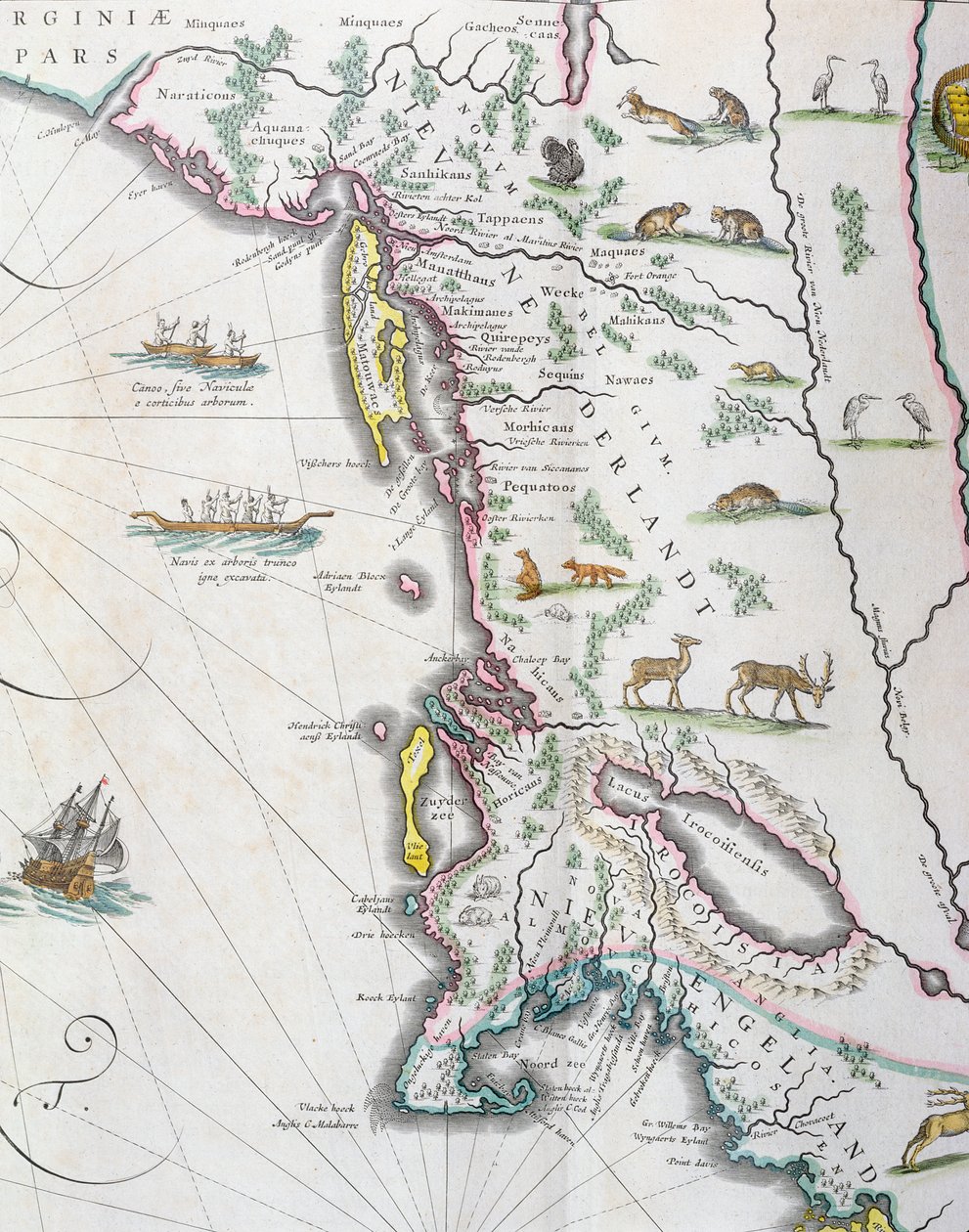
Map Depicting the East Coast of North America, 1647 by Joan Blaeu

Map Depicting the East Coast of North America, 1647

(Map depicting the East Coast of North America, 1647 (see 93602 and 216517))


Joan Blaeu

€ 133.67
Enthält 13.5% MwSt.
   Configure art print
1647  ·  colour lithograph  ·  Picture ID: 190032

Nonclassified artists  ·  Cartography

Map Depicting the East Coast of North America, 1647 by Joan Blaeu. Available as an art print on canvas, photo paper, watercolor board, uncoated paper or Japanese paper.
upside down · dutch ship · native american · indian canoes · boats · Private Collection / Bridgeman Images
Other color variations of this picture  
AR/3D   View in 3D / AR zu Favoriten hinzufügen   Add to favorites    Select wall color    View painting in a room
0 Reviews

Configure art print

Picture Frame

Medium & Stretcher

Glass & Passepartout

Miscellaneous & Extras

 Save / compare configuration
Preview Icon

Summary

Gemälde
Veredelung
Keilrahmen
Museumslizenz

€ 133.67
(inkl. 20% MwSt)
   Add to cart

Bildschärfe: PERFEKT

Should you desire adjustments to brightness and color, or a custom crop of the motif, we are happy to make these changes at no additional cost to you. Please do not hesitate to contact us.

Similar artworks selected for you

Map depicting the East Coast of North America Map of Coast of Virginia, from Theatrum Orbis Terrarum Map of Nova Belgica or New Belgium and of Anglia Nova or New England Map of New Belgium and New England Extreme northeast coastline of the States, in Madagascar and East African Coastline, detail from a world atlas, 1565 Cape Finisterre after the portulan of Luca J. Waghenaer tresoor de zeevaert, Leiden 1592 America, plate 17 from Gold Yielding Regions of Peru, Volume VII, Atlas Maior, by Joan Blaeu The Famous West Indian Voyage Made by the English Fleet of 23 Ships and Barks Illustration from the Queen Mary Atlas New and Accurate Map of the Bishoprics of Stavanger and Bergen Map of Southern Africa (published in Strasbourg in 1522) Route of Drake New Belgium, plate from Map of America Created by Joan Blaeu Map Engraved by Bellin After Earlier Voyages New Netherland and New England, 1682 North Atlantic and South America, Volume XI, Atlas Maior Map of Africa, India, Indian Ocean and East Indies Theatrum Orbis Terrarum Map of polar regions, by Dutch cartographer Willem Janszoon Blaeu Map of New Belgium with a View of New Amsterdam, compiled by Nicolaes Visscher c.1651-55 Peru, in Fol.13 Map of South America and the Magellan Straits, from an Atlas, 1571 California or New Carolina - Theater of the Works, Apostles of the Society of Jesus in North America Croatia, Bosnia and Herzegovina, Serbia, North Albania, Montenegro Map of the Kingdom of Dalmatia, on the coast of the Gulf of Venice (Adriatic Sea)
Show more similar artworks

Other art prints by Joan Blaeu

Map of East Prussia Map of Spoleto Luxembourg, the Capital of the Duchy Italy, Map of Pesaro, from Theatrum civitatum et admirandorum Italiae by Joan Blaeu, engraving View of Villa d General View of the Observatory of Uraniborg, constructed c.1584 by Tycho Brahe (1546-1601) on the island of Hven, Denmark from Map of Rome, Engraving from Theatrum Civitates et Admirandorum Italiae Map of Assisi from Theatrum Civitates et Admirandorum Italiae New and Map of the Travels of Alexander the Great (356-323 BC) from Map of New Belgium and New England Plan of the Castle and Observatory of Uraniborg, Constructed c.1584 by Tycho Brahe on the Island of Hven, Denmark from Europe Map From: Atlas Maior Map of Velletri from Theatrum civitatum et admirandorum Italiae View of old square in Bologna, engraving by Giacomo Lauro and Joan Blaeu from Theatrum civitatum et admirandorum Italiae, published in Amsterdam in 1663
Discover more works by Joan Blaeu

Other motives from the category Cartography

The Polar Aurora, from a Collection of Dutch Marine Maps (detail) Map of Sixteenth Century Japan (from the Map of Ireland showing the Provinces of Ulster, Munster, Connaught and Leinster, by Johann B. Homann, c.1730 Map of Turkey, Middle East Horn of Africa and Persian Gulf in the 1890s, from Map of Siberia and China from Le Theatre du Monde or Nouvel Atlas, 1645 Map of Louvain, from Map of New France dedicated to Colbert by Duchesneau, Intendant, 1681 Map of the parish of St Giles in the Fields, London Map of Lancaster Divided into Hundreds, 1610 World map, illustration from Atlas Geographique Moderne by Prosper-Auguste Poulain de Bossay, c.1850 Map of Le Marais, Paris Map of Alexander the Great The Pacific Ocean, from an Atlas of the World in 33 Maps, Venice, 1st September 1553 Map of Paris depicting the city Map of the south of England, including London, Surrey and Sussex
View More from "Cartography"

Excerpt from our top sellers

Noonday heat Composition, 1930 View from a Window The Apple Harvest The Kiss Eiger, Monk and Jungfrau in Morning Sun Alpine Hut in Rainy Weather Grützner Benedictine Monk with Wine at Breakfast Song of Shambhala The Garden of the Artist in Wannsee, 1918 The Harvesters Luncheon of the Boating Party De Munnekeholm with the Aduardergasthuis in the Foreground and the West-Indisch Huis in the Background Annunciation (post restoration) The Savage State from The Course of Empire
Show More Artworks


What our customers think about us


Frequently Asked Questions about Meisterdrucke


Personalizing your art print at Meisterdrucke is a simple and intuitive process that allows you to design an artwork exactly to your specifications: Choose a frame, determine the image size, decide on a printing medium, and add suitable glazing or a stretcher frame. We also offer customization options such as mats, fillets, and spacers. Our customer service is available to help you design your perfect artwork.

At Meisterdrucke, you have the fascinating option to visualize the artwork you configured directly in your own space. For a tailored preview, simply upload a photo of your room and let the artwork appear on it. If you visit us via a mobile device, be it a phone or tablet, our augmented reality feature brings the image to life and seamlessly projects it into your space. An experience that uniquely combines art and technology.

Choosing the medium is often a matter of personal taste. To give you a clearer idea, we have provided some images for each medium. For a holistic experience, we also offer you a sample set of all paper variants so you can make a decision not just visually but also haptically. You can take advantage of the sample set free of charge – only the shipping costs will apply. You can order the sample set directly.

Do not worry. At Meisterdrucke, we do not proceed mechanically. We manually review each order. If there are any inconsistencies or peculiarities in the configuration, we will immediately contact you. Of course, our courteous and patient support is always at your side to assist you with the configuration. Together with you, we adjust your image by phone or email so that the final result exactly meets your expectations.


Do you have any questions?

Are you interested in an art print from our manufactory but still unsure? Do you need advice on choosing the medium or help with the order?

Our experts are happy to assist you.

+43 4257 29415
support@meisterdrucke.com
Mo-Do: 7:00 - 16:00 | Fr: 7:00 - 13:00

Do you have any questions?

Are you interested in an art print from our manufactory but still unsure? Do you need advice on choosing the medium or help with the order?

Our experts are happy to assist you.

+43 4257 29415
support@meisterdrucke.com
Mo-Do: 7:00 - 16:00 | Fr: 7:00 - 13:00


Meisterdrucke

   Kärntner Strasse 46
        9586 Finkenstein am Faaker See
        Austria
        +43 4257 29415
        support@meisterdrucke.com
Other languages

                   
Erfahrungen & Bewertungen zu Meisterdrucke
Post.at DHL Express Quehenberger Cargoboard
Kaiser Franz Joseph

Meisterdrucke
Kärntner Strasse 46
9586 Finkenstein am Faaker See · Austria
+43 4257 29415 · office@meisterdrucke.com
Post.at DHL Express Quehenberger Cargoboard


Meisterdrucke 2759 Bewertungen auf ProvenExpert.com

(c) 2025 meisterdrucke.ie